Liniewo geodata
Liniewo (Pomerania) is a populated place; located in Poland in Europe/Warsaw (GMT+2) time zone. With population of 1,052 people, there are 2402 cities with bigger population in this country. Compared to other cities in Poland, 95% of cities are located further ↓South; 72.1% of cities are located further →East and 58.7% of cities have higher elevation than Liniewo. Note1


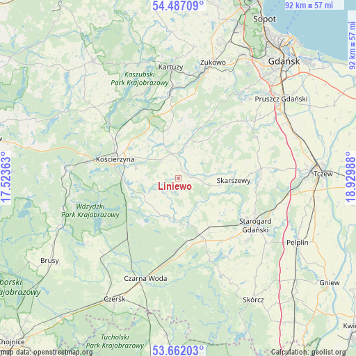
Liniewo GPS coordinates[2]
54° 4' 35.796" North, 18° 13' 36.3" East
| Map corner | latitude | longitude |
|---|---|---|
| Upper-left | 54.48709°, | 17.52363° |
| Center: | 54.07661°, | 18.22675° |
| Lower-right: | 53.66203°, | 18.92988° |
| Map W x H: | 91.7×91.7 km | = 57×57mi |
| max Lat: | 54.83135° ⇑5% North |
| Liniewo: | 54.07661° |
| min Lat: | ⇓95% South 49.21328° |
| min Long | Liniewo | max Long |
| 14.20249° | 18.22675° | 24.03723° |
| W 27.9%⇐ | ⇒72.1% E |
Elevation
Elevation of Liniewo is 149 m = 489 ft, and this is 42.4 m = 139 ft below average elevation for this country.
| Max E: |
974 m = 3196 ft | 58.7% |
| Avg. | 191.4 m = 628 ft | |
| Liniewo | 149 m = 489 ft | |
Min E: |
-3 m = -10 ft | 41.3% |
See also: Poland elevation on elevation.city.
Geographical zone
Liniewo is located in North temperate zone (between Tropic of Cancer and the Arctic Circle). Distance of this North polar circle is 1388.4 km =862.7 mi to North.| Distance of | km | miles | from Liniewo |
|---|---|---|---|
| North Pole | 3994.3 | 2481.9 | to North |
| Arctic Circle | 1388.4 | 862.7 | to North |
| Tropic Cancer | 3406.8 | 2116.9 | to South |
| Equator | 6012.8 | 3736.2 | to South |


Nearby cities:
15 places around Liniewo: (largest is in red/bold)
• Grabowo Kościerskie
11.4 km =7.1 mi,  332°
332°
• Kaliska
19 km =11.8 mi,  181°
181°
• Kolbudy
26.6 km =16.5 mi,  35°
35°
• Kościerzyna
16.8 km =10.4 mi,  287°
287°
• Nowa Karczma
6.5 km =4 mi,  345°
345°
• Przywidz
14.6 km =9.1 mi,  24°
24°
• Pręgowo
25.7 km =16 mi, 39°
• Skarszewy
14.2 km =8.8 mi,  93°
93°
• Somonino
22.2 km =13.8 mi,  355°
355°
• Stara Kiszewa
10.3 km =6.4 mi,  201°
201°
• Starogard Gdański
23.2 km =14.4 mi,  122°
122°
• Stężyca
22.8 km =14.2 mi,  309°
309°
• Trąbki Wielkie
22.9 km =14.2 mi,  62°
62°
• Zblewo
17.1 km =10.6 mi,  158°
158°
• Zduny
27 km =16.8 mi,  105°
105°
Sources, notices
• [Note1] Compared only with cities in Poland existing in our database
• [Src1] Map data: © OpenStreetMap contributors (CC-BY-SA)
• [Src2] Other city data from geonames.org with taken over terms of usage.
• [Src3] Geographical zone / Annual Mean Temperature by Robert A. Rohde @ Wikipedia
