Słońsk geodata
Słońsk (Lubusz) is a seat of a third-order administrative division; located in Poland in Europe/Warsaw (GMT+2) time zone. With population of 3,000 people, there are 1040 cities with bigger population in this country. Compared to other cities in Poland, 77.3% of cities are located further ↓South; 98.8% of cities are located further →East and 97.9% of cities have higher elevation than Słońsk. Note1


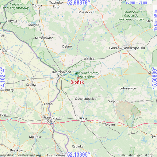
Słońsk GPS coordinates[2]
52° 33' 48.42" North, 14° 48' 18.936" East
| Map corner | latitude | longitude |
|---|---|---|
| Upper-left | 52.98879°, | 14.10214° |
| Center: | 52.56345°, | 14.80526° |
| Lower-right: | 52.13395°, | 15.50839° |
| Map W x H: | 95×95 km | = 59×59mi |
| max Lat: | 54.83135° ⇑22.7% North |
| Słońsk: | 52.56345° |
| min Lat: | ⇓77.3% South 49.21328° |
| min Long | Słońsk | max Long |
| 14.20249° | 14.80526° | 24.03723° |
| W 1.2%⇐ | ⇒98.8% E |
Elevation
Elevation of Słońsk is 16 m = 52 ft, and this is 175.4 m = 575 ft below average elevation for this country.
| Max E: |
974 m = 3196 ft | 97.9% |
| Avg. | 191.4 m = 628 ft | |
| Słońsk | 16 m = 52 ft | |
Min E: |
-3 m = -10 ft | 2.1% |
See also: Poland elevation on elevation.city.
Geographical zone
Słońsk is located in North temperate zone (between Tropic of Cancer and the Arctic Circle). Distance of this North polar circle is 1556.7 km =967.3 mi to North.| Distance of | km | miles | from Słońsk |
|---|---|---|---|
| North Pole | 4162.6 | 2586.5 | to North |
| Arctic Circle | 1556.7 | 967.3 | to North |
| Tropic Cancer | 3238.6 | 2012.4 | to South |
| Equator | 5844.5 | 3631.6 | to South |


Nearby cities:
15 places around Słońsk: (largest is in red/bold)
• Bogdaniec
22.7 km =14.1 mi,  52°
52°
• Boleszkowice
24 km =14.9 mi,  318°
318°
• Cychry
15.9 km =9.9 mi,  334°
334°
• Dargomyśl
19.2 km =11.9 mi, 326°
• Dębno
20.8 km =12.9 mi,  339°
339°
• Górzyca
12.7 km =7.9 mi,  232°
232°
• Jenin
24.7 km =15.3 mi, 53°
• Kostrzyn nad Odrą
10.8 km =6.7 mi,  284°
284°
• Krzeszyce
13.8 km =8.6 mi,  80°
80°
• Lemierzyce
7.4 km =4.6 mi,  87°
87°
• Oborzany
21.6 km =13.4 mi, 334°
• Ośno Lubuskie
13.1 km =8.1 mi,  158°
158°
• Rzepin
24.2 km =15 mi,  175°
175°
• Sarbinowo
13.6 km =8.5 mi, 320°
• Witnica
13.7 km =8.5 mi,  27°
27°
Sources, notices
• [Note1] Compared only with cities in Poland existing in our database
• [Src1] Map data: © OpenStreetMap contributors (CC-BY-SA)
• [Src2] Other city data from geonames.org with taken over terms of usage.
• [Src3] Geographical zone / Annual Mean Temperature by Robert A. Rohde @ Wikipedia
