Lemierzyce geodata
Lemierzyce (Lubusz) is a populated place; located in Poland in Europe/Warsaw (GMT+2) time zone. With population of 630 people, there are 3202 cities with bigger population in this country. Compared to other cities in Poland, 77.4% of cities are located further ↓South; 98.5% of cities are located further →East and 96.1% of cities have higher elevation than Lemierzyce. Note1


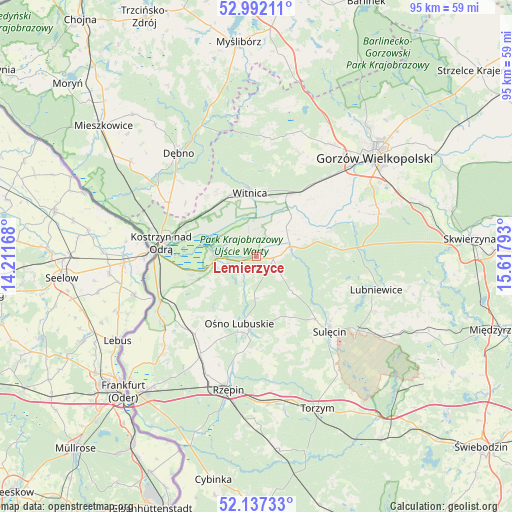
Lemierzyce GPS coordinates[2]
52° 34' 0.48" North, 14° 54' 53.28" East
| Map corner | latitude | longitude |
|---|---|---|
| Upper-left | 52.99211°, | 14.21168° |
| Center: | 52.5668°, | 14.9148° |
| Lower-right: | 52.13733°, | 15.61793° |
| Map W x H: | 95×95 km | = 59×59mi |
| max Lat: | 54.83135° ⇑22.6% North |
| Lemierzyce: | 52.5668° |
| min Lat: | ⇓77.4% South 49.21328° |
| min Long | Lemierzyce | max Long |
| 14.20249° | 14.9148° | 24.03723° |
| W 1.5%⇐ | ⇒98.5% E |
Elevation
Elevation of Lemierzyce is 31 m = 102 ft, and this is 160.4 m = 526 ft below average elevation for this country.
| Max E: |
974 m = 3196 ft | 96.1% |
| Avg. | 191.4 m = 628 ft | |
| Lemierzyce | 31 m = 102 ft | |
Min E: |
-3 m = -10 ft | 3.9% |
See also: Poland elevation on elevation.city.
Geographical zone
Lemierzyce is located in North temperate zone (between Tropic of Cancer and the Arctic Circle). Distance of this North polar circle is 1556.3 km =967 mi to North.| Distance of | km | miles | from Lemierzyce |
|---|---|---|---|
| North Pole | 4162.2 | 2586.3 | to North |
| Arctic Circle | 1556.3 | 967 | to North |
| Tropic Cancer | 3239 | 2012.6 | to South |
| Equator | 5844.9 | 3631.9 | to South |


Nearby cities:
15 places around Lemierzyce: (largest is in red/bold)
• Bogdaniec
17.2 km =10.7 mi,  37°
37°
• Cychry
20 km =12.4 mi,  314°
314°
• Dargomyśl
23.9 km =14.9 mi, 310°
• Górzyca
19.3 km =12 mi,  245°
245°
• Jenin
19 km =11.8 mi, 40°
• Kostrzyn nad Odrą
18.1 km =11.2 mi,  277°
277°
• Krzeszyce
6.5 km =4 mi,  73°
73°
• Lubiszyn
23.9 km =14.9 mi,  5°
5°
• Lubniewice
23.4 km =14.5 mi,  103°
103°
• Ośno Lubuskie
12.9 km =8 mi,  191°
191°
• Sarbinowo
19 km =11.8 mi,  302°
302°
• Sulęcin
19.3 km =12 mi,  134°
134°
• Słońsk
7.4 km =4.6 mi,  267°
267°
• Witnica
11.9 km =7.4 mi,  354°
354°
• Łupowo
20.5 km =12.7 mi, 42°
Sources, notices
• [Note1] Compared only with cities in Poland existing in our database
• [Src1] Map data: © OpenStreetMap contributors (CC-BY-SA)
• [Src2] Other city data from geonames.org with taken over terms of usage.
• [Src3] Geographical zone / Annual Mean Temperature by Robert A. Rohde @ Wikipedia
