Bogdaniec geodata
Bogdaniec (Lubusz) is a seat of a third-order administrative division; located in Poland in Europe/Warsaw (GMT+2) time zone. With population of 1,100 people, there are 2307 cities with bigger population in this country. Compared to other cities in Poland, 79.1% of cities are located further ↓South; 97.5% of cities are located further →East and 96.7% of cities have higher elevation than Bogdaniec. Note1


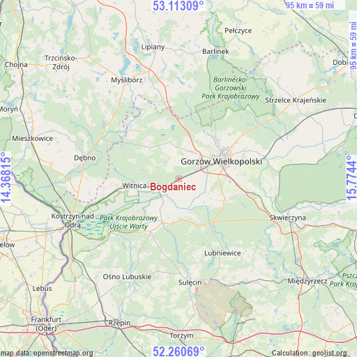
Bogdaniec GPS coordinates[2]
52° 41' 20.292" North, 15° 4' 16.572" East
| Map corner | latitude | longitude |
|---|---|---|
| Upper-left | 53.11309°, | 14.36815° |
| Center: | 52.68897°, | 15.07127° |
| Lower-right: | 52.26069°, | 15.7744° |
| Map W x H: | 94.8×94.8 km | = 58.9×58.9mi |
| max Lat: | 54.83135° ⇑20.9% North |
| Bogdaniec: | 52.68897° |
| min Lat: | ⇓79.1% South 49.21328° |
| min Long | Bogdaniec | max Long |
| 14.20249° | 15.07127° | 24.03723° |
| W 2.5%⇐ | ⇒97.5% E |
Elevation
Elevation of Bogdaniec is 24 m = 79 ft, and this is 167.4 m = 549 ft below average elevation for this country.
| Max E: |
974 m = 3196 ft | 96.7% |
| Avg. | 191.4 m = 628 ft | |
| Bogdaniec | 24 m = 79 ft | |
Min E: |
-3 m = -10 ft | 3.3% |
See also: Poland elevation on elevation.city.
Geographical zone
Bogdaniec is located in North temperate zone (between Tropic of Cancer and the Arctic Circle). Distance of this North polar circle is 1542.7 km =958.6 mi to North.| Distance of | km | miles | from Bogdaniec |
|---|---|---|---|
| North Pole | 4148.6 | 2577.8 | to North |
| Arctic Circle | 1542.7 | 958.6 | to North |
| Tropic Cancer | 3252.5 | 2021 | to South |
| Equator | 5858.5 | 3640.3 | to South |


Nearby cities:
15 places around Bogdaniec: (largest is in red/bold)
• Baczyna
7.9 km =4.9 mi,  21°
21°
• Deszczno
16.9 km =10.5 mi,  97°
97°
• Gorzów Wielkopolski
11.9 km =7.4 mi,  63°
63°
• Gralewo
22.2 km =13.8 mi,  72°
72°
• Jenin
2 km =1.2 mi, 65°
• Krzeszyce
12.5 km =7.8 mi,  200°
200°
• Kłodawa
14.5 km =9 mi,  41°
41°
• Lemierzyce
17.2 km =10.7 mi,  217°
217°
• Lubiszyn
13.2 km =8.2 mi,  320°
320°
• Lubniewice
22.7 km =14.1 mi,  147°
147°
• Słońsk
22.7 km =14.1 mi,  232°
232°
• Trzcinna
21.9 km =13.6 mi,  349°
349°
• Witnica
11.8 km =7.3 mi,  261°
261°
• Wysoka
10 km =6.2 mi, 347°
• Łupowo
3.7 km =2.3 mi, 66°
Sources, notices
• [Note1] Compared only with cities in Poland existing in our database
• [Src1] Map data: © OpenStreetMap contributors (CC-BY-SA)
• [Src2] Other city data from geonames.org with taken over terms of usage.
• [Src3] Geographical zone / Annual Mean Temperature by Robert A. Rohde @ Wikipedia
