Dargomyśl geodata
Dargomyśl (West Pomerania) is a populated place; located in Poland in Europe/Warsaw (GMT+2) time zone. With population of 598 people, there are 3292 cities with bigger population in this country. Compared to other cities in Poland, 79.4% of cities are located further ↓South; 99.3% of cities are located further →East and 95.6% of cities have higher elevation than Dargomyśl. Note1


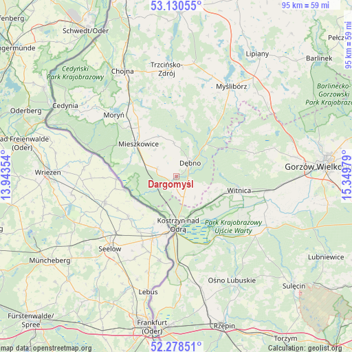
Dargomyśl GPS coordinates[2]
52° 42' 23.796" North, 14° 38' 47.976" East
| Map corner | latitude | longitude |
|---|---|---|
| Upper-left | 53.13055°, | 13.94354° |
| Center: | 52.70661°, | 14.64666° |
| Lower-right: | 52.27851°, | 15.34979° |
| Map W x H: | 94.7×94.7 km | = 58.8×58.8mi |
| max Lat: | 54.83135° ⇑20.6% North |
| Dargomyśl: | 52.70661° |
| min Lat: | ⇓79.4% South 49.21328° |
| min Long | Dargomyśl | max Long |
| 14.20249° | 14.64666° | 24.03723° |
| W 0.7%⇐ | ⇒99.3% E |
Elevation
Elevation of Dargomyśl is 35 m = 115 ft, and this is 156.4 m = 513 ft below average elevation for this country.
| Max E: |
974 m = 3196 ft | 95.6% |
| Avg. | 191.4 m = 628 ft | |
| Dargomyśl | 35 m = 115 ft | |
Min E: |
-3 m = -10 ft | 4.4% |
See also: Poland elevation on elevation.city.
Geographical zone
Dargomyśl is located in North temperate zone (between Tropic of Cancer and the Arctic Circle). Distance of this North polar circle is 1540.7 km =957.3 mi to North.| Distance of | km | miles | from Dargomyśl |
|---|---|---|---|
| North Pole | 4146.6 | 2576.6 | to North |
| Arctic Circle | 1540.7 | 957.3 | to North |
| Tropic Cancer | 3254.5 | 2022.3 | to South |
| Equator | 5860.4 | 3641.5 | to South |


Nearby cities:
15 places around Dargomyśl: (largest is in red/bold)
• Bielin
18.8 km =11.7 mi,  316°
316°
• Boleszkowice
5.6 km =3.5 mi,  291°
291°
• Cychry
4.2 km =2.6 mi,  110°
110°
• Dębno
5 km =3.1 mi,  43°
43°
• Górzyca
23.6 km =14.7 mi,  178°
178°
• Kostrzyn nad Odrą
13.3 km =8.3 mi, 179°
• Lemierzyce
23.9 km =14.9 mi,  130°
130°
• Lubiszyn
21.9 km =13.6 mi,  67°
67°
• Mieszkowice
13.7 km =8.5 mi,  311°
311°
• Oborzany
3.7 km =2.3 mi,  19°
19°
• Sarbinowo
5.8 km =3.6 mi,  160°
160°
• Słońsk
19.2 km =11.9 mi,  146°
146°
• Troszyn
9.2 km =5.7 mi, 320°
• Witnica
17.3 km =10.7 mi,  102°
102°
• Witnica
21.6 km =13.4 mi,  327°
327°
Sources, notices
• [Note1] Compared only with cities in Poland existing in our database
• [Src1] Map data: © OpenStreetMap contributors (CC-BY-SA)
• [Src2] Other city data from geonames.org with taken over terms of usage.
• [Src3] Geographical zone / Annual Mean Temperature by Robert A. Rohde @ Wikipedia
