Górzyca geodata
Górzyca (Lubusz) is a seat of a third-order administrative division; located in Poland in Europe/Warsaw (GMT+2) time zone. With population of 1,539 people, there are 1815 cities with bigger population in this country. Compared to other cities in Poland, 76.4% of cities are located further ↓South; 99.3% of cities are located further →East and 97% of cities have higher elevation than Górzyca. Note1


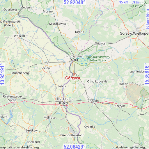
Górzyca GPS coordinates[2]
52° 29' 40.092" North, 14° 39' 18.108" East
| Map corner | latitude | longitude |
|---|---|---|
| Upper-left | 52.92048°, | 13.95191° |
| Center: | 52.49447°, | 14.65503° |
| Lower-right: | 52.06429°, | 15.35816° |
| Map W x H: | 95.2×95.2 km | = 59.2×59.2mi |
| max Lat: | 54.83135° ⇑23.6% North |
| Górzyca: | 52.49447° |
| min Lat: | ⇓76.4% South 49.21328° |
| min Long | Górzyca | max Long |
| 14.20249° | 14.65503° | 24.03723° |
| W 0.7%⇐ | ⇒99.3% E |
Elevation
Elevation of Górzyca is 21 m = 69 ft, and this is 170.4 m = 559 ft below average elevation for this country.
| Max E: |
974 m = 3196 ft | 97% |
| Avg. | 191.4 m = 628 ft | |
| Górzyca | 21 m = 69 ft | |
Min E: |
-3 m = -10 ft | 3% |
See also: Poland elevation on elevation.city.
Geographical zone
Górzyca is located in North temperate zone (between Tropic of Cancer and the Arctic Circle). Distance of this North polar circle is 1564.3 km =972 mi to North.| Distance of | km | miles | from Górzyca |
|---|---|---|---|
| North Pole | 4170.2 | 2591.2 | to North |
| Arctic Circle | 1564.3 | 972 | to North |
| Tropic Cancer | 3230.9 | 2007.6 | to South |
| Equator | 5836.8 | 3626.8 | to South |


Nearby cities:
15 places around Górzyca: (largest is in red/bold)
• Boczów
27.5 km =17.1 mi,  134°
134°
• Boleszkowice
26.3 km =16.3 mi,  347°
347°
• Cychry
22.4 km =13.9 mi,  8°
8°
• Dargomyśl
23.6 km =14.7 mi,  358°
358°
• Dębno
27.3 km =17 mi, 6°
• Kostrzyn nad Odrą
10.3 km =6.4 mi, 357°
• Krzeszyce
25.8 km =16 mi,  67°
67°
• Lemierzyce
19.3 km =12 mi, 65°
• Oborzany
27.1 km =16.8 mi,  1°
1°
• Ośno Lubuskie
15.6 km =9.7 mi,  106°
106°
• Rzepin
20.4 km =12.7 mi,  143°
143°
• Sarbinowo
18.2 km =11.3 mi, 4°
• Słońsk
12.7 km =7.9 mi,  52°
52°
• Słubice
17.2 km =10.7 mi,  201°
201°
• Witnica
25.8 km =16 mi,  39°
39°
Sources, notices
• [Note1] Compared only with cities in Poland existing in our database
• [Src1] Map data: © OpenStreetMap contributors (CC-BY-SA)
• [Src2] Other city data from geonames.org with taken over terms of usage.
• [Src3] Geographical zone / Annual Mean Temperature by Robert A. Rohde @ Wikipedia
