Sarbinowo geodata
Sarbinowo (West Pomerania) is a populated place; located in Poland in Europe/Warsaw (GMT+2) time zone. With population of 512 people, there are 3510 cities with bigger population in this country. Compared to other cities in Poland, 78.7% of cities are located further ↓South; 99.2% of cities are located further →East and 92.9% of cities have higher elevation than Sarbinowo. Note1


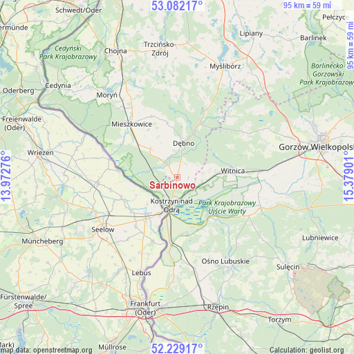
Sarbinowo GPS coordinates[2]
52° 39' 27.9" North, 14° 40' 33.168" East
| Map corner | latitude | longitude |
|---|---|---|
| Upper-left | 53.08217°, | 13.97276° |
| Center: | 52.65775°, | 14.67588° |
| Lower-right: | 52.22917°, | 15.37901° |
| Map W x H: | 94.8×94.8 km | = 58.9×58.9mi |
| max Lat: | 54.83135° ⇑21.3% North |
| Sarbinowo: | 52.65775° |
| min Lat: | ⇓78.7% South 49.21328° |
| min Long | Sarbinowo | max Long |
| 14.20249° | 14.67588° | 24.03723° |
| W 0.8%⇐ | ⇒99.2% E |
Elevation
Elevation of Sarbinowo is 60 m = 197 ft, and this is 131.4 m = 431 ft below average elevation for this country.
| Max E: |
974 m = 3196 ft | 92.9% |
| Avg. | 191.4 m = 628 ft | |
| Sarbinowo | 60 m = 197 ft | |
Min E: |
-3 m = -10 ft | 7.1% |
See also: Poland elevation on elevation.city.
Geographical zone
Sarbinowo is located in North temperate zone (between Tropic of Cancer and the Arctic Circle). Distance of this North polar circle is 1546.2 km =960.8 mi to North.| Distance of | km | miles | from Sarbinowo |
|---|---|---|---|
| North Pole | 4152.1 | 2580 | to North |
| Arctic Circle | 1546.2 | 960.8 | to North |
| Tropic Cancer | 3249.1 | 2018.9 | to South |
| Equator | 5855 | 3638.1 | to South |


Nearby cities:
15 places around Sarbinowo: (largest is in red/bold)
• Bielin
24.2 km =15 mi,  321°
321°
• Boleszkowice
10.4 km =6.5 mi, 316°
• Cychry
4.4 km =2.7 mi,  26°
26°
• Dargomyśl
5.8 km =3.6 mi,  340°
340°
• Dębno
9.2 km =5.7 mi,  9°
9°
• Górzyca
18.2 km =11.3 mi,  184°
184°
• Kostrzyn nad Odrą
8.1 km =5 mi,  192°
192°
• Krzeszyce
23.8 km =14.8 mi,  110°
110°
• Lemierzyce
19 km =11.8 mi,  122°
122°
• Lubiszyn
22.9 km =14.2 mi,  53°
53°
• Mieszkowice
18.9 km =11.7 mi, 319°
• Oborzany
9 km =5.6 mi,  355°
355°
• Słońsk
13.6 km =8.5 mi,  140°
140°
• Troszyn
14.8 km =9.2 mi,  328°
328°
• Witnica
15.1 km =9.4 mi,  83°
83°
Sources, notices
• [Note1] Compared only with cities in Poland existing in our database
• [Src1] Map data: © OpenStreetMap contributors (CC-BY-SA)
• [Src2] Other city data from geonames.org with taken over terms of usage.
• [Src3] Geographical zone / Annual Mean Temperature by Robert A. Rohde @ Wikipedia
