Więcbork geodata
Więcbork (Kujawsko-Pomorskie) is a seat of a third-order administrative division; located in Poland in Europe/Warsaw (GMT+2) time zone. With population of 5,953 people, there are 608 cities with bigger population in this country. Compared to other cities in Poland, 88.1% of cities are located further ↓South; 79.9% of cities are located further →East and 74% of cities have higher elevation than Więcbork. Note1
Administrative division(s):
- Level 1: Kujawsko-Pomorskie
- Level 2: Powiat sępoleński
- Level 3: Więcbork


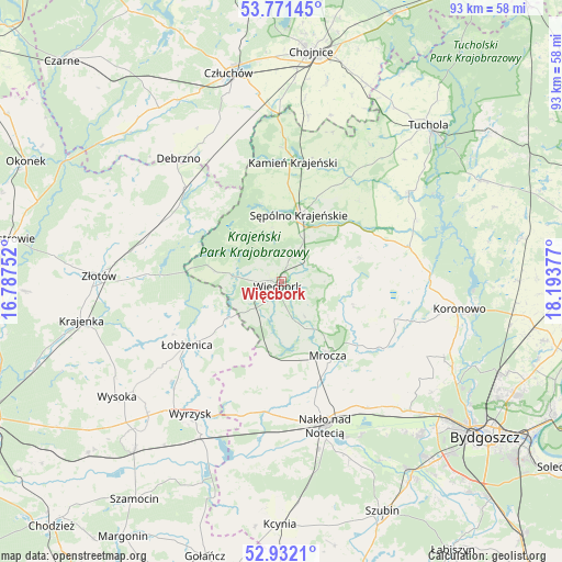
Więcbork GPS coordinates[2]
53° 21' 13.824" North, 17° 29' 26.304" East
| Map corner | latitude | longitude |
|---|---|---|
| Upper-left | 53.77145°, | 16.78752° |
| Center: | 53.35384°, | 17.49064° |
| Lower-right: | 52.9321°, | 18.19377° |
| Map W x H: | 93.3×93.3 km | = 58×58mi |
| max Lat: | 54.83135° ⇑11.9% North |
| Więcbork: | 53.35384° |
| min Lat: | ⇓88.1% South 49.21328° |
| min Long | Więcbork | max Long |
| 14.20249° | 17.49064° | 24.03723° |
| W 20.1%⇐ | ⇒79.9% E |
Elevation
Elevation of Więcbork is 113 m = 371 ft, and this is 78.4 m = 257 ft below average elevation for this country.
| Max E: |
974 m = 3196 ft | 74% |
| Avg. | 191.4 m = 628 ft | |
| Więcbork | 113 m = 371 ft | |
Min E: |
-3 m = -10 ft | 26% |
See also: Poland elevation on elevation.city.
Geographical zone
Więcbork is located in North temperate zone (between Tropic of Cancer and the Arctic Circle). Distance of this North polar circle is 1468.8 km =912.7 mi to North.| Distance of | km | miles | from Więcbork |
|---|---|---|---|
| North Pole | 4074.7 | 2531.9 | to North |
| Arctic Circle | 1468.8 | 912.7 | to North |
| Tropic Cancer | 3326.5 | 2067 | to South |
| Equator | 5932.4 | 3686.2 | to South |


Nearby cities:
15 places around Więcbork: (largest is in red/bold)
• Debrzno
26.5 km =16.5 mi,  320°
320°
• Gostycyn
26 km =16.2 mi,  54°
54°
• Kamienica
25.3 km =15.7 mi,  56°
56°
• Kamień Krajeński
20.1 km =12.5 mi,  5°
5°
• Lipka
22.4 km =13.9 mi,  314°
314°
• Mrocza
14.4 km =8.9 mi,  148°
148°
• Nakło nad Notecią
24.7 km =15.3 mi,  162°
162°
• Sadki
21.7 km =13.5 mi,  187°
187°
• Sicienko
26.5 km =16.5 mi,  128°
128°
• Sośno
13.6 km =8.5 mi,  73°
73°
• Sypniewo
11 km =6.8 mi,  279°
279°
• Sępólno Krajeńskie
11.2 km =7 mi, 14°
• Zakrzewo
23.2 km =14.4 mi,  286°
286°
• Łobżenica
18.6 km =11.6 mi,  236°
236°
• Ślesin
25.3 km =15.7 mi, 146°
Sources, notices
• [Note1] Compared only with cities in Poland existing in our database
• [Src1] Map data: © OpenStreetMap contributors (CC-BY-SA)
• [Src2] Other city data from geonames.org with taken over terms of usage.
• [Src3] Geographical zone / Annual Mean Temperature by Robert A. Rohde @ Wikipedia
