Mrocza geodata
Mrocza (Kujawsko-Pomorskie) is a seat of a third-order administrative division; located in Poland in Europe/Warsaw (GMT+2) time zone. With population of 4,347 people, there are 761 cities with bigger population in this country. Compared to other cities in Poland, 86.8% of cities are located further ↓South; 79.1% of cities are located further →East and 78.4% of cities have higher elevation than Mrocza. Note1


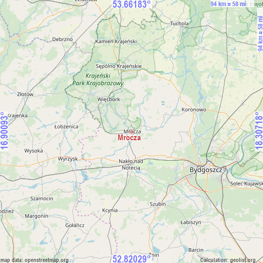
Mrocza GPS coordinates[2]
53° 14' 35.268" North, 17° 36' 14.58" East
| Map corner | latitude | longitude |
|---|---|---|
| Upper-left | 53.66183°, | 16.90093° |
| Center: | 53.24313°, | 17.60405° |
| Lower-right: | 52.82029°, | 18.30718° |
| Map W x H: | 93.6×93.6 km | = 58.2×58.2mi |
| max Lat: | 54.83135° ⇑13.2% North |
| Mrocza: | 53.24313° |
| min Lat: | ⇓86.8% South 49.21328° |
| min Long | Mrocza | max Long |
| 14.20249° | 17.60405° | 24.03723° |
| W 20.9%⇐ | ⇒79.1% E |
Elevation
Elevation of Mrocza is 103 m = 338 ft, and this is 88.4 m = 290 ft below average elevation for this country.
| Max E: |
974 m = 3196 ft | 78.4% |
| Avg. | 191.4 m = 628 ft | |
| Mrocza | 103 m = 338 ft | |
Min E: |
-3 m = -10 ft | 21.6% |
See also: Poland elevation on elevation.city.
Geographical zone
Mrocza is located in North temperate zone (between Tropic of Cancer and the Arctic Circle). Distance of this North polar circle is 1481.1 km =920.3 mi to North.| Distance of | km | miles | from Mrocza |
|---|---|---|---|
| North Pole | 4087 | 2539.5 | to North |
| Arctic Circle | 1481.1 | 920.3 | to North |
| Tropic Cancer | 3314.2 | 2059.3 | to South |
| Equator | 5920.1 | 3678.6 | to South |


Nearby cities:
15 places around Mrocza: (largest is in red/bold)
• Białe Błota
26.5 km =16.5 mi,  128°
128°
• Koronowo
23.5 km =14.6 mi,  70°
70°
• Kołaczkowo
26.2 km =16.3 mi,  152°
152°
• Nakło nad Notecią
11.2 km =7 mi,  180°
180°
• Osiek nad Notecią
24.9 km =15.5 mi,  236°
236°
• Sadki
13.8 km =8.6 mi,  228°
228°
• Sicienko
13.8 km =8.6 mi,  108°
108°
• Sośno
17.2 km =10.7 mi,  18°
18°
• Sypniewo
23.2 km =14.4 mi,  307°
307°
• Szubin
27.5 km =17.1 mi,  160°
160°
• Sępólno Krajeńskie
23.7 km =14.7 mi,  348°
348°
• Więcbork
14.4 km =8.9 mi,  328°
328°
• Wyrzysk
24.5 km =15.2 mi,  245°
245°
• Łobżenica
23.3 km =14.5 mi,  275°
275°
• Ślesin
10.9 km =6.8 mi,  142°
142°
Sources, notices
• [Note1] Compared only with cities in Poland existing in our database
• [Src1] Map data: © OpenStreetMap contributors (CC-BY-SA)
• [Src2] Other city data from geonames.org with taken over terms of usage.
• [Src3] Geographical zone / Annual Mean Temperature by Robert A. Rohde @ Wikipedia
