Skomlin geodata
Skomlin (Łódź Voivodeship) is a populated place; located in Poland in Europe/Warsaw (GMT+2) time zone. With population of 1,656 people, there are 1719 cities with bigger population in this country. Compared to other cities in Poland, 50.2% of cities are located further ↓South; 70% of cities are located further →East and 55% of cities have lower elevation than Skomlin. Note1


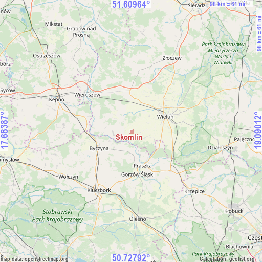
Skomlin GPS coordinates[2]
51° 10' 15.204" North, 18° 23' 13.164" East
| Map corner | latitude | longitude |
|---|---|---|
| Upper-left | 51.60964°, | 17.68387° |
| Center: | 51.17089°, | 18.38699° |
| Lower-right: | 50.72792°, | 19.09012° |
| Map W x H: | 98×98 km | = 60.9×60.9mi |
| max Lat: | 54.83135° ⇑49.8% North |
| Skomlin: | 51.17089° |
| min Lat: | ⇓50.2% South 49.21328° |
| min Long | Skomlin | max Long |
| 14.20249° | 18.38699° | 24.03723° |
| W 30%⇐ | ⇒70% E |
Elevation
Elevation of Skomlin is 185 m = 607 ft, and this is 6.4 m = 21 ft below average elevation for this country.
| Max E: |
974 m = 3196 ft | 45% |
| Avg. | 191.4 m = 628 ft | |
| Skomlin | 185 m = 607 ft | |
Min E: |
-3 m = -10 ft | 55% |
See also: Poland elevation on elevation.city.
Geographical zone
Skomlin is located in North temperate zone (between Tropic of Cancer and the Arctic Circle). Distance of this North polar circle is 1711.5 km =1063.5 mi to North.| Distance of | km | miles | from Skomlin |
|---|---|---|---|
| North Pole | 4317.4 | 2682.7 | to North |
| Arctic Circle | 1711.5 | 1063.5 | to North |
| Tropic Cancer | 3083.8 | 1916.2 | to South |
| Equator | 5689.7 | 3535.4 | to South |


Nearby cities:
15 places around Skomlin: (largest is in red/bold)
• Bolesławiec
14 km =8.7 mi,  282°
282°
• Byczyna
13.6 km =8.5 mi,  242°
242°
• Czastary
10.8 km =6.7 mi,  334°
334°
• Dzietrzkowice
4.5 km =2.8 mi,  251°
251°
• Kowale
11.8 km =7.3 mi,  148°
148°
• Mieleszyn
15 km =9.3 mi,  301°
301°
• Mokrsko
7.2 km =4.5 mi,  82°
82°
• Ożarów
9.1 km =5.7 mi,  108°
108°
• Praszka
13.8 km =8.6 mi,  160°
160°
• Przedmość
9.3 km =5.8 mi, 158°
• Walichnowy
13.9 km =8.6 mi,  358°
358°
• Wieluń
13.9 km =8.6 mi,  66°
66°
• Wróblew
3.1 km =1.9 mi, 155°
• Zdziechowice
8.3 km =5.2 mi,  178°
178°
• Łubnice
6.8 km =4.2 mi,  263°
263°
Sources, notices
• [Note1] Compared only with cities in Poland existing in our database
• [Src1] Map data: © OpenStreetMap contributors (CC-BY-SA)
• [Src2] Other city data from geonames.org with taken over terms of usage.
• [Src3] Geographical zone / Annual Mean Temperature by Robert A. Rohde @ Wikipedia
