Przedmość geodata
Przedmość (Opole Voivodeship) is a populated place; located in Poland in Europe/Warsaw (GMT+2) time zone. With population of 650 people, there are 3162 cities with bigger population in this country. Compared to other cities in Poland, 52.8% of cities are located further ↑North; 69% of cities are located further →East and 57.5% of cities have lower elevation than Przedmość. Note1


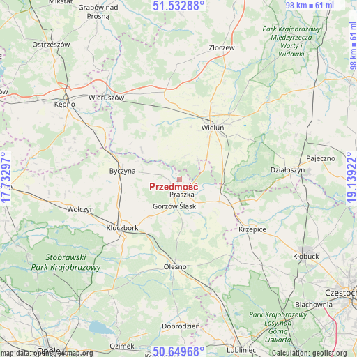
Przedmość GPS coordinates[2]
51° 5' 36.204" North, 18° 26' 9.924" East
| Map corner | latitude | longitude |
|---|---|---|
| Upper-left | 51.53288°, | 17.73297° |
| Center: | 51.09339°, | 18.43609° |
| Lower-right: | 50.64968°, | 19.13922° |
| Map W x H: | 98.2×98.2 km | = 61×61mi |
| max Lat: | 54.83135° ⇑52.8% North |
| Przedmość: | 51.09339° |
| min Lat: | ⇓47.2% South 49.21328° |
| min Long | Przedmość | max Long |
| 14.20249° | 18.43609° | 24.03723° |
| W 31%⇐ | ⇒69% E |
Elevation
Elevation of Przedmość is 192 m = 630 ft, and this is 0.59999999999999 m = 2 ft above average elevation for this country.
| Max E: |
974 m = 3196 ft | 42.5% |
| Przedmość | 192 m 630 ft | |
| Avg. | 191.4 m = 628 ft | |
Min E: |
-3 m = -10 ft | 57.5% |
See also: Poland elevation on elevation.city.
Geographical zone
Przedmość is located in North temperate zone (between Tropic of Cancer and the Arctic Circle). Distance of this North polar circle is 1720.1 km =1068.8 mi to North.| Distance of | km | miles | from Przedmość |
|---|---|---|---|
| North Pole | 4326 | 2688.1 | to North |
| Arctic Circle | 1720.1 | 1068.8 | to North |
| Tropic Cancer | 3075.1 | 1910.8 | to South |
| Equator | 5681.1 | 3530.1 | to South |


Nearby cities:
15 places around Przedmość: (largest is in red/bold)
• Byczyna
15.7 km =9.8 mi,  278°
278°
• Dalachów
10.1 km =6.3 mi,  100°
100°
• Dzietrzkowice
10.6 km =6.6 mi,  312°
312°
• Gorzów Śląski
7.2 km =4.5 mi,  187°
187°
• Kowale
3.1 km =1.9 mi,  119°
119°
• Mokrsko
10.2 km =6.3 mi,  21°
21°
• Ożarów
7.8 km =4.8 mi,  42°
42°
• Praszka
4.6 km =2.9 mi,  164°
164°
• Pątnów
13.8 km =8.6 mi,  65°
65°
• Rudniki
12.9 km =8 mi, 118°
• Skomlin
9.3 km =5.8 mi,  338°
338°
• Wieluń
17 km =10.6 mi,  33°
33°
• Wróblew
6.2 km =3.9 mi, 339°
• Zdziechowice
3.2 km =2 mi,  274°
274°
• Łubnice
12.8 km =8 mi, 307°
Sources, notices
• [Note1] Compared only with cities in Poland existing in our database
• [Src1] Map data: © OpenStreetMap contributors (CC-BY-SA)
• [Src2] Other city data from geonames.org with taken over terms of usage.
• [Src3] Geographical zone / Annual Mean Temperature by Robert A. Rohde @ Wikipedia
