Czastary geodata
Czastary (Łódź Voivodeship) is a seat of a third-order administrative division; located in Poland in Europe/Warsaw (GMT+2) time zone. With population of 1,024 people, there are 2425 cities with bigger population in this country. Compared to other cities in Poland, 52.3% of cities are located further ↓South; 71.1% of cities are located further →East and 56.8% of cities have lower elevation than Czastary. Note1
Administrative division(s):
- Level 1: Łódź Voivodeship
- Level 2: Powiat wieruszowski
- Level 3: Czastary


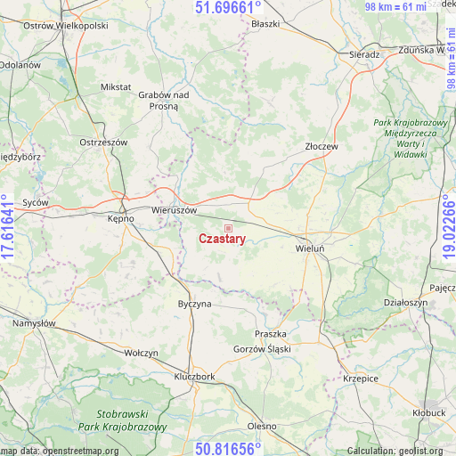
Czastary GPS coordinates[2]
51° 15' 31.284" North, 18° 19' 10.308" East
| Map corner | latitude | longitude |
|---|---|---|
| Upper-left | 51.69661°, | 17.61641° |
| Center: | 51.25869°, | 18.31953° |
| Lower-right: | 50.81656°, | 19.02266° |
| Map W x H: | 97.9×97.8 km | = 60.8×60.8mi |
| max Lat: | 54.83135° ⇑47.7% North |
| Czastary: | 51.25869° |
| min Lat: | ⇓52.3% South 49.21328° |
| min Long | Czastary | max Long |
| 14.20249° | 18.31953° | 24.03723° |
| W 28.9%⇐ | ⇒71.1% E |
Elevation
Elevation of Czastary is 190 m = 623 ft, and this is 1.4 m = 5 ft below average elevation for this country.
| Max E: |
974 m = 3196 ft | 43.2% |
| Avg. | 191.4 m = 628 ft | |
| Czastary | 190 m = 623 ft | |
Min E: |
-3 m = -10 ft | 56.8% |
See also: Poland elevation on elevation.city.
Geographical zone
Czastary is located in North temperate zone (between Tropic of Cancer and the Arctic Circle). Distance of this North polar circle is 1701.7 km =1057.4 mi to North.| Distance of | km | miles | from Czastary |
|---|---|---|---|
| North Pole | 4307.6 | 2676.6 | to North |
| Arctic Circle | 1701.7 | 1057.4 | to North |
| Tropic Cancer | 3093.5 | 1922.2 | to South |
| Equator | 5699.4 | 3541.4 | to South |


Nearby cities:
15 places around Czastary: (largest is in red/bold)
• Bolesławiec
11.1 km =6.9 mi,  233°
233°
• Dzietrzkowice
11.2 km =7 mi,  177°
177°
• Galewice
10.5 km =6.5 mi,  335°
335°
• Lututów
14.8 km =9.2 mi,  32°
32°
• Mieleszyn
8.2 km =5.1 mi,  256°
256°
• Mokrsko
14.7 km =9.1 mi,  126°
126°
• Opatów
13 km =8.1 mi,  247°
247°
• Osiek
14.7 km =9.1 mi,  325°
325°
• Siemianice
15.1 km =9.4 mi, 234°
• Skomlin
10.8 km =6.7 mi,  154°
154°
• Sokolniki
5.5 km =3.4 mi,  9°
9°
• Walichnowy
5.9 km =3.7 mi,  45°
45°
• Wieruszów
12.1 km =7.5 mi,  289°
289°
• Wróblew
14 km =8.7 mi, 154°
• Łubnice
10.7 km =6.6 mi,  190°
190°
Sources, notices
• [Note1] Compared only with cities in Poland existing in our database
• [Src1] Map data: © OpenStreetMap contributors (CC-BY-SA)
• [Src2] Other city data from geonames.org with taken over terms of usage.
• [Src3] Geographical zone / Annual Mean Temperature by Robert A. Rohde @ Wikipedia
