Byczyna geodata
Byczyna (Opole Voivodeship) is a seat of a third-order administrative division; located in Poland in Europe/Warsaw (GMT+2) time zone. With population of 3,665 people, there are 880 cities with bigger population in this country. Compared to other cities in Poland, 52.1% of cities are located further ↑North; 72.4% of cities are located further →East and 59.4% of cities have lower elevation than Byczyna. Note1


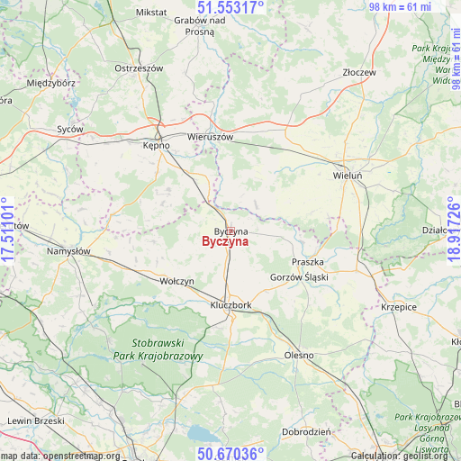
Byczyna GPS coordinates[2]
51° 6' 49.932" North, 18° 12' 50.868" East
| Map corner | latitude | longitude |
|---|---|---|
| Upper-left | 51.55317°, | 17.51101° |
| Center: | 51.11387°, | 18.21413° |
| Lower-right: | 50.67036°, | 18.91726° |
| Map W x H: | 98.2×98.2 km | = 61×61mi |
| max Lat: | 54.83135° ⇑52.1% North |
| Byczyna: | 51.11387° |
| min Lat: | ⇓47.9% South 49.21328° |
| min Long | Byczyna | max Long |
| 14.20249° | 18.21413° | 24.03723° |
| W 27.6%⇐ | ⇒72.4% E |
Elevation
Elevation of Byczyna is 199 m = 653 ft, and this is 7.6 m = 25 ft above average elevation for this country.
| Max E: |
974 m = 3196 ft | 40.6% |
| Byczyna | 199 m 653 ft | |
| Avg. | 191.4 m = 628 ft | |
Min E: |
-3 m = -10 ft | 59.4% |
See also: Poland elevation on elevation.city.
Geographical zone
Byczyna is located in North temperate zone (between Tropic of Cancer and the Arctic Circle). Distance of this North polar circle is 1717.8 km =1067.4 mi to North.| Distance of | km | miles | from Byczyna |
|---|---|---|---|
| North Pole | 4323.7 | 2686.6 | to North |
| Arctic Circle | 1717.8 | 1067.4 | to North |
| Tropic Cancer | 3077.4 | 1912.2 | to South |
| Equator | 5683.3 | 3531.4 | to South |


Nearby cities:
15 places around Byczyna: (largest is in red/bold)
• Bolesławiec
9.6 km =6 mi,  350°
350°
• Dzietrzkowice
9.2 km =5.7 mi,  57°
57°
• Gorzów Śląski
17.4 km =10.8 mi,  122°
122°
• Kluczbork
15.7 km =9.8 mi,  178°
178°
• Mieleszyn
14.2 km =8.8 mi,  357°
357°
• Opatów
12.2 km =7.6 mi,  337°
337°
• Przedmość
15.7 km =9.8 mi,  98°
98°
• Siemianice
8.8 km =5.5 mi,  325°
325°
• Skomlin
13.6 km =8.5 mi, 62°
• Trzcinica
15.8 km =9.8 mi,  292°
292°
• Wołczyn
15.6 km =9.7 mi,  227°
227°
• Wróblew
13.8 km =8.6 mi,  75°
75°
• Zdziechowice
12.4 km =7.7 mi, 99°
• Łubnice
7.7 km =4.8 mi,  43°
43°
• Łęka Opatowska
13.2 km =8.2 mi, 325°
Sources, notices
• [Note1] Compared only with cities in Poland existing in our database
• [Src1] Map data: © OpenStreetMap contributors (CC-BY-SA)
• [Src2] Other city data from geonames.org with taken over terms of usage.
• [Src3] Geographical zone / Annual Mean Temperature by Robert A. Rohde @ Wikipedia
