Bolesławiec geodata
Bolesławiec (Łódź Voivodeship) is a populated place; located in Poland in Europe/Warsaw (GMT+2) time zone. With population of 1,500 people, there are 1837 cities with bigger population in this country. Compared to other cities in Poland, 51% of cities are located further ↓South; 72.8% of cities are located further →East and 52.5% of cities have higher elevation than Bolesławiec. Note1
Administrative division(s):
- Level 1: Łódź Voivodeship
- Level 2: Powiat wieruszowski
- Level 3: Bolesławiec


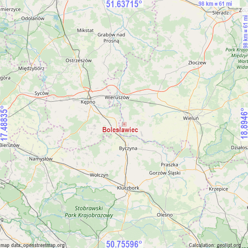
Bolesławiec GPS coordinates[2]
51° 11' 55.176" North, 18° 11' 29.292" East
| Map corner | latitude | longitude |
|---|---|---|
| Upper-left | 51.63715°, | 17.48835° |
| Center: | 51.19866°, | 18.19147° |
| Lower-right: | 50.75596°, | 18.8946° |
| Map W x H: | 98×98 km | = 60.9×60.9mi |
| max Lat: | 54.83135° ⇑49% North |
| Bolesławiec: | 51.19866° |
| min Lat: | ⇓51% South 49.21328° |
| min Long | Bolesławiec | max Long |
| 14.20249° | 18.19147° | 24.03723° |
| W 27.2%⇐ | ⇒72.8% E |
Elevation
Elevation of Bolesławiec is 165 m = 541 ft, and this is 26.4 m = 87 ft below average elevation for this country.
| Max E: |
974 m = 3196 ft | 52.5% |
| Avg. | 191.4 m = 628 ft | |
| Bolesławiec | 165 m = 541 ft | |
Min E: |
-3 m = -10 ft | 47.5% |
See also: Poland elevation on elevation.city.
Geographical zone
Bolesławiec is located in North temperate zone (between Tropic of Cancer and the Arctic Circle). Distance of this North polar circle is 1708.4 km =1061.6 mi to North.| Distance of | km | miles | from Bolesławiec |
|---|---|---|---|
| North Pole | 4314.3 | 2680.8 | to North |
| Arctic Circle | 1708.4 | 1061.6 | to North |
| Tropic Cancer | 3086.8 | 1918 | to South |
| Equator | 5692.8 | 3537.3 | to South |


Nearby cities:
15 places around Bolesławiec: (largest is in red/bold)
• Baranów
14.9 km =9.3 mi,  298°
298°
• Byczyna
9.6 km =6 mi,  170°
170°
• Czastary
11.1 km =6.9 mi,  53°
53°
• Dzietrzkowice
10.4 km =6.5 mi,  115°
115°
• Mieleszyn
4.9 km =3 mi,  10°
10°
• Opatów
3.6 km =2.2 mi, 299°
• Siemianice
4 km =2.5 mi,  237°
237°
• Skomlin
14 km =8.7 mi,  102°
102°
• Sokolniki
15.6 km =9.7 mi,  39°
39°
• Słupia pod Kępnem
11.3 km =7 mi,  293°
293°
• Trzcinica
13.5 km =8.4 mi,  254°
254°
• Wieruszów
11 km =6.8 mi,  346°
346°
• Wróblew
16.1 km =10 mi,  111°
111°
• Łubnice
7.9 km =4.9 mi, 119°
• Łęka Opatowska
6.1 km =3.8 mi,  284°
284°
Sources, notices
• [Note1] Compared only with cities in Poland existing in our database
• [Src1] Map data: © OpenStreetMap contributors (CC-BY-SA)
• [Src2] Other city data from geonames.org with taken over terms of usage.
• [Src3] Geographical zone / Annual Mean Temperature by Robert A. Rohde @ Wikipedia
