Wieluń geodata
Wieluń (Łódź Voivodeship) is a populated place; located in Poland in Europe/Warsaw (GMT+2) time zone. With population of 24,384 people, there are 198 cities with bigger population in this country. Compared to other cities in Poland, 51.4% of cities are located further ↓South; 67.1% of cities are located further →East and 53% of cities have lower elevation than Wieluń. Note1


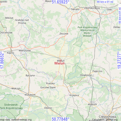
Wieluń GPS coordinates[2]
51° 13' 15.492" North, 18° 34' 10.704" East
| Map corner | latitude | longitude |
|---|---|---|
| Upper-left | 51.65925°, | 17.86652° |
| Center: | 51.22097°, | 18.56964° |
| Lower-right: | 50.77848°, | 19.27277° |
| Map W x H: | 97.9×97.9 km | = 60.8×60.8mi |
| max Lat: | 54.83135° ⇑48.6% North |
| Wieluń: | 51.22097° |
| min Lat: | ⇓51.4% South 49.21328° |
| min Long | Wieluń | max Long |
| 14.20249° | 18.56964° | 24.03723° |
| W 32.9%⇐ | ⇒67.1% E |
Elevation
Elevation of Wieluń is 180 m = 591 ft, and this is 11.4 m = 37 ft below average elevation for this country.
| Max E: |
974 m = 3196 ft | 47% |
| Avg. | 191.4 m = 628 ft | |
| Wieluń | 180 m = 591 ft | |
Min E: |
-3 m = -10 ft | 53% |
See also: Poland elevation on elevation.city.
Geographical zone
Wieluń is located in North temperate zone (between Tropic of Cancer and the Arctic Circle). Distance of this North polar circle is 1705.9 km =1060 mi to North.| Distance of | km | miles | from Wieluń |
|---|---|---|---|
| North Pole | 4311.8 | 2679.2 | to North |
| Arctic Circle | 1705.9 | 1060 | to North |
| Tropic Cancer | 3089.3 | 1919.6 | to South |
| Equator | 5695.2 | 3538.8 | to South |


Nearby cities:
15 places around Wieluń: (largest is in red/bold)
• Czarnożyły
7.2 km =4.5 mi,  355°
355°
• Czastary
17.9 km =11.1 mi,  283°
283°
• Dalachów
16 km =9.9 mi,  177°
177°
• Kowale
17.1 km =10.6 mi,  202°
202°
• Masłowice
6.2 km =3.9 mi,  49°
49°
• Mokrsko
7.3 km =4.5 mi,  230°
230°
• Osjaków
17.2 km =10.7 mi,  63°
63°
• Ostrówek
13.3 km =8.3 mi,  16°
16°
• Ożarów
9.4 km =5.8 mi,  205°
205°
• Przedmość
17 km =10.6 mi, 213°
• Pątnów
9.2 km =5.7 mi,  159°
159°
• Skomlin
13.9 km =8.6 mi,  246°
246°
• Walichnowy
15.6 km =9.7 mi,  302°
302°
• Wierzchlas
6.9 km =4.3 mi,  105°
105°
• Wróblew
14.2 km =8.8 mi, 233°
Sources, notices
• [Note1] Compared only with cities in Poland existing in our database
• [Src1] Map data: © OpenStreetMap contributors (CC-BY-SA)
• [Src2] Other city data from geonames.org with taken over terms of usage.
• [Src3] Geographical zone / Annual Mean Temperature by Robert A. Rohde @ Wikipedia
