Zduny geodata
Zduny (Pomerania) is a populated place; located in Poland in Europe/Warsaw (GMT+2) time zone. With population of 616 people, there are 3237 cities with bigger population in this country. Compared to other cities in Poland, 94.4% of cities are located further ↓South; 66.1% of cities are located further →East and 92% of cities have higher elevation than Zduny. Note1
Administrative division(s):
- Level 1: Pomerania
- Level 2: Powiat starogardzki
- Level 3: Starogard Gdański


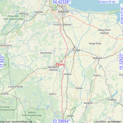
Zduny GPS coordinates[2]
54° 0' 43.776" North, 18° 37' 34.032" East
| Map corner | latitude | longitude |
|---|---|---|
| Upper-left | 54.42328°, | 17.923° |
| Center: | 54.01216°, | 18.62612° |
| Lower-right: | 53.59694°, | 19.32925° |
| Map W x H: | 91.9×91.9 km | = 57.1×57.1mi |
| max Lat: | 54.83135° ⇑5.6% North |
| Zduny: | 54.01216° |
| min Lat: | ⇓94.4% South 49.21328° |
| min Long | Zduny | max Long |
| 14.20249° | 18.62612° | 24.03723° |
| W 33.9%⇐ | ⇒66.1% E |
Elevation
Elevation of Zduny is 65 m = 213 ft, and this is 126.4 m = 415 ft below average elevation for this country.
| Max E: |
974 m = 3196 ft | 92% |
| Avg. | 191.4 m = 628 ft | |
| Zduny | 65 m = 213 ft | |
Min E: |
-3 m = -10 ft | 8% |
See also: Poland elevation on elevation.city.
Geographical zone
Zduny is located in North temperate zone (between Tropic of Cancer and the Arctic Circle). Distance of this North polar circle is 1395.6 km =867.2 mi to North.| Distance of | km | miles | from Zduny |
|---|---|---|---|
| North Pole | 4001.5 | 2486.4 | to North |
| Arctic Circle | 1395.6 | 867.2 | to North |
| Tropic Cancer | 3399.7 | 2112.5 | to South |
| Equator | 6005.6 | 3731.7 | to South |


Nearby cities:
15 places around Zduny: (largest is in red/bold)
• Bobowo
15 km =9.3 mi,  197°
197°
• Czarlin
9.9 km =6.2 mi,  63°
63°
• Lichnowy
22 km =13.7 mi, 58°
• Lisewo Malborskie
16.3 km =10.1 mi,  54°
54°
• Miłoradz
19.1 km =11.9 mi,  89°
89°
• Morzeszczyn
19.6 km =12.2 mi,  167°
167°
• Pelplin
10.4 km =6.5 mi,  153°
153°
• Pszczółki
18.5 km =11.5 mi,  14°
14°
• Skarszewy
13.5 km =8.4 mi,  298°
298°
• Starogard Gdański
8.4 km =5.2 mi,  230°
230°
• Subkowy
9.4 km =5.8 mi,  96°
96°
• Tczew
13.3 km =8.3 mi, 47°
• Trąbki Wielkie
18.5 km =11.5 mi,  342°
342°
• Wielkie Walichnowy
18.2 km =11.3 mi,  125°
125°
• Zblewo
21.7 km =13.5 mi,  246°
246°
Sources, notices
• [Note1] Compared only with cities in Poland existing in our database
• [Src1] Map data: © OpenStreetMap contributors (CC-BY-SA)
• [Src2] Other city data from geonames.org with taken over terms of usage.
• [Src3] Geographical zone / Annual Mean Temperature by Robert A. Rohde @ Wikipedia
