Siewierz geodata
Siewierz (Silesia) is a seat of a third-order administrative division; located in Poland in Europe/Warsaw (GMT+2) time zone. With population of 5,417 people, there are 648 cities with bigger population in this country. Compared to other cities in Poland, 67.9% of cities are located further ↑North; 55.4% of cities are located further →East and 86.6% of cities have lower elevation than Siewierz. Note1


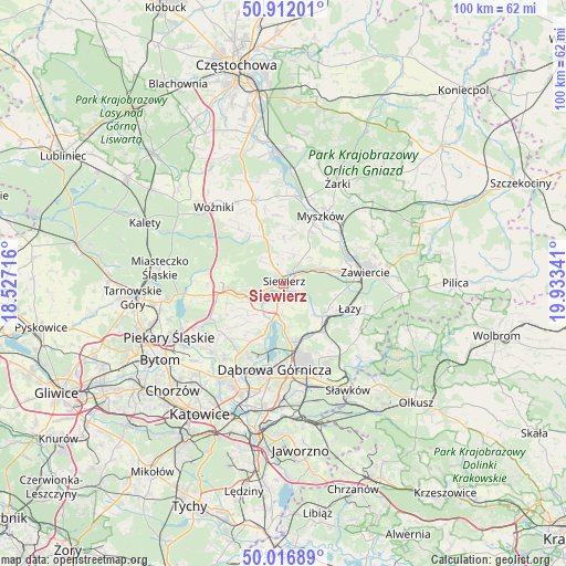
Siewierz GPS coordinates[2]
50° 27' 59.652" North, 19° 13' 49.008" East
| Map corner | latitude | longitude |
|---|---|---|
| Upper-left | 50.91201°, | 18.52716° |
| Center: | 50.46657°, | 19.23028° |
| Lower-right: | 50.01689°, | 19.93341° |
| Map W x H: | 99.5×99.5 km | = 61.8×61.8mi |
| max Lat: | 54.83135° ⇑67.9% North |
| Siewierz: | 50.46657° |
| min Lat: | ⇓32.1% South 49.21328° |
| min Long | Siewierz | max Long |
| 14.20249° | 19.23028° | 24.03723° |
| W 44.6%⇐ | ⇒55.4% E |
Elevation
Elevation of Siewierz is 299 m = 981 ft, and this is 107.6 m = 353 ft above average elevation for this country.
| Max E: |
974 m = 3196 ft | 13.4% |
| Siewierz | 299 m 981 ft | |
| Avg. | 191.4 m = 628 ft | |
Min E: |
-3 m = -10 ft | 86.6% |
See also: Poland elevation on elevation.city.
Geographical zone
Siewierz is located in North temperate zone (between Tropic of Cancer and the Arctic Circle). Distance of this North polar circle is 1789.8 km =1112.1 mi to North.| Distance of | km | miles | from Siewierz |
|---|---|---|---|
| North Pole | 4395.7 | 2731.4 | to North |
| Arctic Circle | 1789.8 | 1112.1 | to North |
| Tropic Cancer | 3005.4 | 1867.5 | to South |
| Equator | 5611.4 | 3486.8 | to South |


Nearby cities:
15 places around Siewierz: (largest is in red/bold)
• Chruszczobród
9 km =5.6 mi,  130°
130°
• Ciągowice
9.7 km =6 mi,  102°
102°
• Cynków
13.2 km =8.2 mi,  323°
323°
• Koziegłówki
13.8 km =8.6 mi,  346°
346°
• Mierzęcice
7.5 km =4.7 mi,  251°
251°
• Myszków
13.8 km =8.6 mi,  28°
28°
• Ożarowice
13.3 km =8.3 mi,  267°
267°
• Pińczyce
7.9 km =4.9 mi,  358°
358°
• Poręba
8.1 km =5 mi,  72°
72°
• Psary
12.6 km =7.8 mi,  220°
220°
• Sarnów
11.8 km =7.3 mi,  208°
208°
• Strzyżowice
13.8 km =8.6 mi,  230°
230°
• Wysoka
9.6 km =6 mi,  115°
115°
• Zawiercie
13.4 km =8.3 mi,  79°
79°
• Łazy
12.4 km =7.7 mi,  110°
110°
Sources, notices
• [Note1] Compared only with cities in Poland existing in our database
• [Src1] Map data: © OpenStreetMap contributors (CC-BY-SA)
• [Src2] Other city data from geonames.org with taken over terms of usage.
• [Src3] Geographical zone / Annual Mean Temperature by Robert A. Rohde @ Wikipedia
