Myszków geodata
Myszków (Silesia) is a seat of a third-order administrative division; located in Poland in Europe/Warsaw (GMT+2) time zone. With population of 33,273 people, there are 155 cities with bigger population in this country. Compared to other cities in Poland, 65.8% of cities are located further ↑North; 54% of cities are located further →East and 85.8% of cities have lower elevation than Myszków. Note1


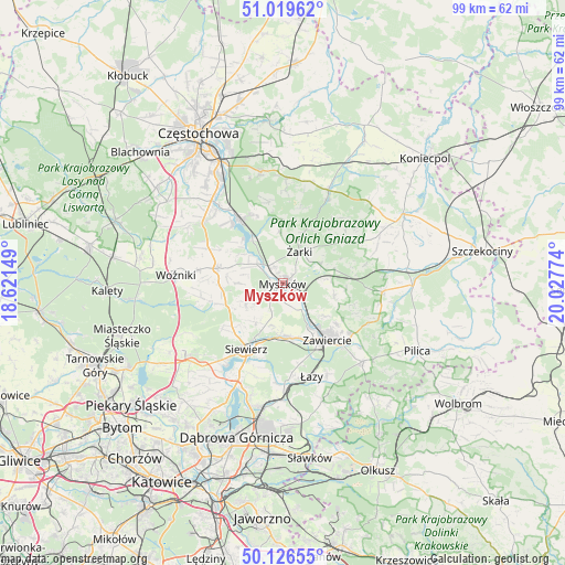
Myszków GPS coordinates[2]
50° 34' 30.72" North, 19° 19' 28.596" East
| Map corner | latitude | longitude |
|---|---|---|
| Upper-left | 51.01962°, | 18.62149° |
| Center: | 50.5752°, | 19.32461° |
| Lower-right: | 50.12655°, | 20.02774° |
| Map W x H: | 99.3×99.3 km | = 61.7×61.7mi |
| max Lat: | 54.83135° ⇑65.8% North |
| Myszków: | 50.5752° |
| min Lat: | ⇓34.2% South 49.21328° |
| min Long | Myszków | max Long |
| 14.20249° | 19.32461° | 24.03723° |
| W 46%⇐ | ⇒54% E |
Elevation
Elevation of Myszków is 294 m = 965 ft, and this is 102.6 m = 337 ft above average elevation for this country.
| Max E: |
974 m = 3196 ft | 14.2% |
| Myszków | 294 m 965 ft | |
| Avg. | 191.4 m = 628 ft | |
Min E: |
-3 m = -10 ft | 85.8% |
See also: Poland elevation on elevation.city.
Geographical zone
Myszków is located in North temperate zone (between Tropic of Cancer and the Arctic Circle). Distance of this North polar circle is 1777.7 km =1104.6 mi to North.| Distance of | km | miles | from Myszków |
|---|---|---|---|
| North Pole | 4383.6 | 2723.8 | to North |
| Arctic Circle | 1777.7 | 1104.6 | to North |
| Tropic Cancer | 3017.5 | 1875 | to South |
| Equator | 5623.4 | 3494.2 | to South |


Nearby cities:
15 places around Myszków: (largest is in red/bold)
• Choroń
12.7 km =7.9 mi,  339°
339°
• Góra Włodowska
8.7 km =5.4 mi,  88°
88°
• Jaworznik
6.9 km =4.3 mi,  57°
57°
• Koziegłowy
11.7 km =7.3 mi,  283°
283°
• Koziegłówki
10 km =6.2 mi, 277°
• Lgota Górna
6.4 km =4 mi,  295°
295°
• Pińczyce
8 km =5 mi,  238°
238°
• Poręba
9.7 km =6 mi,  173°
173°
• Przybynów
8.7 km =5.4 mi,  356°
356°
• Rudniki
9.6 km =6 mi,  128°
128°
• Wysoka Lelowska
6.8 km =4.2 mi,  7°
7°
• Włodowice
9.2 km =5.7 mi,  103°
103°
• Zawiercie
11.7 km =7.3 mi,  146°
146°
• Żarki
6.2 km =3.9 mi,  26°
26°
• Żarki-Letnisko
6.4 km =4 mi,  326°
326°
Sources, notices
• [Note1] Compared only with cities in Poland existing in our database
• [Src1] Map data: © OpenStreetMap contributors (CC-BY-SA)
• [Src2] Other city data from geonames.org with taken over terms of usage.
• [Src3] Geographical zone / Annual Mean Temperature by Robert A. Rohde @ Wikipedia
