Ciągowice geodata
Ciągowice (Silesia) is a populated place; located in Poland in Europe/Warsaw (GMT+2) time zone. With population of 616 people, there are 3237 cities with bigger population in this country. Compared to other cities in Poland, 68.3% of cities are located further ↑North; 53.2% of cities are located further →East and 91.1% of cities have lower elevation than Ciągowice. Note1


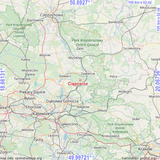
Ciągowice GPS coordinates[2]
50° 26' 49.452" North, 19° 21' 51.948" East
| Map corner | latitude | longitude |
|---|---|---|
| Upper-left | 50.8927°, | 18.66131° |
| Center: | 50.44707°, | 19.36443° |
| Lower-right: | 49.99721°, | 20.06756° |
| Map W x H: | 99.6×99.6 km | = 61.9×61.9mi |
| max Lat: | 54.83135° ⇑68.3% North |
| Ciągowice: | 50.44707° |
| min Lat: | ⇓31.7% South 49.21328° |
| min Long | Ciągowice | max Long |
| 14.20249° | 19.36443° | 24.03723° |
| W 46.8%⇐ | ⇒53.2% E |
Elevation
Elevation of Ciągowice is 346 m = 1135 ft, and this is 154.6 m = 507 ft above average elevation for this country.
| Max E: |
974 m = 3196 ft | 8.9% |
| Ciągowice | 346 m 1135 ft | |
| Avg. | 191.4 m = 628 ft | |
Min E: |
-3 m = -10 ft | 91.1% |
See also: Poland elevation on elevation.city.
Geographical zone
Ciągowice is located in North temperate zone (between Tropic of Cancer and the Arctic Circle). Distance of this North polar circle is 1792 km =1113.5 mi to North.| Distance of | km | miles | from Ciągowice |
|---|---|---|---|
| North Pole | 4397.9 | 2732.7 | to North |
| Arctic Circle | 1792 | 1113.5 | to North |
| Tropic Cancer | 3003.3 | 1866.2 | to South |
| Equator | 5609.2 | 3485.4 | to South |


Nearby cities:
15 places around Ciągowice: (largest is in red/bold)
• Chruszczobród
4.5 km =2.8 mi,  216°
216°
• Góra Włodowska
15.6 km =9.7 mi,  22°
22°
• Krzykawka
15.5 km =9.6 mi,  165°
165°
• Myszków
14.5 km =9 mi,  348°
348°
• Niegowonice
7.7 km =4.8 mi,  147°
147°
• Ogrodzieniec
11 km =6.8 mi,  87°
87°
• Pińczyce
13.9 km =8.6 mi,  316°
316°
• Poręba
4.9 km =3 mi,  338°
338°
• Rokitno Szlacheckie
5.1 km =3.2 mi,  109°
109°
• Rudniki
9.5 km =5.9 mi,  29°
29°
• Siewierz
9.7 km =6 mi,  282°
282°
• Wysoka
2.1 km =1.3 mi,  201°
201°
• Włodowice
13.5 km =8.4 mi, 27°
• Zawiercie
5.8 km =3.6 mi,  39°
39°
• Łazy
3 km =1.9 mi,  135°
135°
Sources, notices
• [Note1] Compared only with cities in Poland existing in our database
• [Src1] Map data: © OpenStreetMap contributors (CC-BY-SA)
• [Src2] Other city data from geonames.org with taken over terms of usage.
• [Src3] Geographical zone / Annual Mean Temperature by Robert A. Rohde @ Wikipedia
