Poręba geodata
Poręba (Silesia) is a populated place; located in Poland in Europe/Warsaw (GMT+2) time zone. With population of 8,718 people, there are 488 cities with bigger population in this country. Compared to other cities in Poland, 67.6% of cities are located further ↑North; 53.7% of cities are located further →East and 88.4% of cities have lower elevation than Poręba. Note1


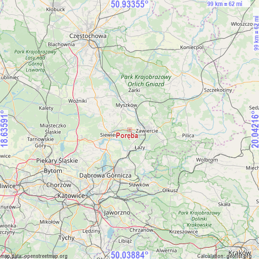
Poręba GPS coordinates[2]
50° 29' 17.916" North, 19° 20' 20.508" East
| Map corner | latitude | longitude |
|---|---|---|
| Upper-left | 50.93355°, | 18.63591° |
| Center: | 50.48831°, | 19.33903° |
| Lower-right: | 50.03884°, | 20.04216° |
| Map W x H: | 99.5×99.5 km | = 61.8×61.8mi |
| max Lat: | 54.83135° ⇑67.6% North |
| Poręba: | 50.48831° |
| min Lat: | ⇓32.4% South 49.21328° |
| min Long | Poręba | max Long |
| 14.20249° | 19.33903° | 24.03723° |
| W 46.3%⇐ | ⇒53.7% E |
Elevation
Elevation of Poręba is 312 m = 1024 ft, and this is 120.6 m = 396 ft above average elevation for this country.
| Max E: |
974 m = 3196 ft | 11.6% |
| Poręba | 312 m 1024 ft | |
| Avg. | 191.4 m = 628 ft | |
Min E: |
-3 m = -10 ft | 88.4% |
See also: Poland elevation on elevation.city.
Geographical zone
Poręba is located in North temperate zone (between Tropic of Cancer and the Arctic Circle). Distance of this North polar circle is 1787.4 km =1110.6 mi to North.| Distance of | km | miles | from Poręba |
|---|---|---|---|
| North Pole | 4393.3 | 2729.9 | to North |
| Arctic Circle | 1787.4 | 1110.6 | to North |
| Tropic Cancer | 3007.9 | 1869 | to South |
| Equator | 5613.8 | 3488.3 | to South |


Nearby cities:
15 places around Poręba: (largest is in red/bold)
• Chruszczobród
8.2 km =5.1 mi,  185°
185°
• Ciągowice
4.9 km =3 mi,  158°
158°
• Góra Włodowska
12.5 km =7.8 mi,  38°
38°
• Jaworznik
14.2 km =8.8 mi,  19°
19°
• Myszków
9.7 km =6 mi,  353°
353°
• Niegowonice
12.5 km =7.8 mi,  151°
151°
• Ogrodzieniec
13.4 km =8.3 mi,  107°
107°
• Pińczyce
9.6 km =6 mi,  304°
304°
• Rokitno Szlacheckie
9.1 km =5.7 mi,  133°
133°
• Rudniki
7.5 km =4.7 mi,  60°
60°
• Siewierz
8.1 km =5 mi,  252°
252°
• Wysoka
6.6 km =4.1 mi,  170°
170°
• Włodowice
10.9 km =6.8 mi,  46°
46°
• Zawiercie
5.5 km =3.4 mi,  90°
90°
• Łazy
7.8 km =4.8 mi, 149°
Sources, notices
• [Note1] Compared only with cities in Poland existing in our database
• [Src1] Map data: © OpenStreetMap contributors (CC-BY-SA)
• [Src2] Other city data from geonames.org with taken over terms of usage.
• [Src3] Geographical zone / Annual Mean Temperature by Robert A. Rohde @ Wikipedia
