Trzyciąż geodata
Trzyciąż (Lesser Poland) is a populated place; located in Poland in Europe/Warsaw (GMT+2) time zone. With population of 720 people, there are 3027 cities with bigger population in this country. Compared to other cities in Poland, 71.8% of cities are located further ↑North; 54.1% of cities are located further ←West and 94.6% of cities have lower elevation than Trzyciąż. Note1


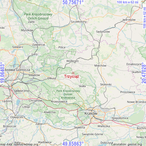
Trzyciąż GPS coordinates[2]
50° 18' 35.244" North, 19° 46' 1.74" East
| Map corner | latitude | longitude |
|---|---|---|
| Upper-left | 50.75671°, | 19.06403° |
| Center: | 50.30979°, | 19.76715° |
| Lower-right: | 49.85863°, | 20.47028° |
| Map W x H: | 99.9×99.9 km | = 62.1×62.1mi |
| max Lat: | 54.83135° ⇑71.8% North |
| Trzyciąż: | 50.30979° |
| min Lat: | ⇓28.2% South 49.21328° |
| min Long | Trzyciąż | max Long |
| 14.20249° | 19.76715° | 24.03723° |
| W 54.1%⇐ | ⇒45.9% E |
Elevation
Elevation of Trzyciąż is 406 m = 1332 ft, and this is 214.6 m = 704 ft above average elevation for this country.
| Max E: |
974 m = 3196 ft | 5.4% |
| Trzyciąż | 406 m 1332 ft | |
| Avg. | 191.4 m = 628 ft | |
Min E: |
-3 m = -10 ft | 94.6% |
See also: Poland elevation on elevation.city.
Geographical zone
Trzyciąż is located in North temperate zone (between Tropic of Cancer and the Arctic Circle). Distance of this North polar circle is 1807.2 km =1122.9 mi to North.| Distance of | km | miles | from Trzyciąż |
|---|---|---|---|
| North Pole | 4413.1 | 2742.2 | to North |
| Arctic Circle | 1807.2 | 1122.9 | to North |
| Tropic Cancer | 2988 | 1856.7 | to South |
| Equator | 5593.9 | 3475.9 | to South |


Nearby cities:
15 places around Trzyciąż: (largest is in red/bold)
• Bębło
14.4 km =8.9 mi,  174°
174°
• Jerzmanowice
10.9 km =6.8 mi,  187°
187°
• Klucze
14.8 km =9.2 mi,  281°
281°
• Olkusz
14.7 km =9.1 mi,  257°
257°
• Osiek
13.9 km =8.6 mi,  238°
238°
• Poręba Górna
5.2 km =3.2 mi,  18°
18°
• Przeginia
9.7 km =6 mi,  215°
215°
• Racławice
14.4 km =8.9 mi,  206°
206°
• Sieniczno
12 km =7.5 mi,  246°
246°
• Skała
10.7 km =6.6 mi,  145°
145°
• Sułoszowa
5.3 km =3.3 mi, 207°
• Sąspów
9 km =5.6 mi,  178°
178°
• Wierzchowisko
8 km =5 mi,  25°
25°
• Wolbrom
7.8 km =4.8 mi,  355°
355°
• Zarzecze
8.1 km =5 mi,  321°
321°
Sources, notices
• [Note1] Compared only with cities in Poland existing in our database
• [Src1] Map data: © OpenStreetMap contributors (CC-BY-SA)
• [Src2] Other city data from geonames.org with taken over terms of usage.
• [Src3] Geographical zone / Annual Mean Temperature by Robert A. Rohde @ Wikipedia
