Sułoszowa geodata
Sułoszowa (Lesser Poland) is a seat of a third-order administrative division; located in Poland in Europe/Warsaw (GMT+2) time zone. With population of 4,200 people, there are 778 cities with bigger population in this country. Compared to other cities in Poland, 72.8% of cities are located further ↑North; 53.4% of cities are located further ←West and 95.2% of cities have lower elevation than Sułoszowa. Note1


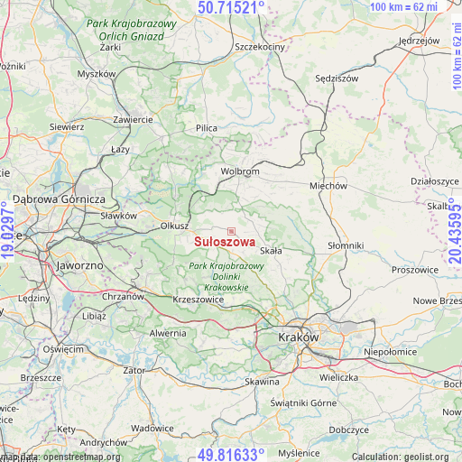
Sułoszowa GPS coordinates[2]
50° 16' 4.404" North, 19° 43' 58.152" East
| Map corner | latitude | longitude |
|---|---|---|
| Upper-left | 50.71521°, | 19.0297° |
| Center: | 50.26789°, | 19.73282° |
| Lower-right: | 49.81633°, | 20.43595° |
| Map W x H: | 99.9×99.9 km | = 62.1×62.1mi |
| max Lat: | 54.83135° ⇑72.8% North |
| Sułoszowa: | 50.26789° |
| min Lat: | ⇓27.2% South 49.21328° |
| min Long | Sułoszowa | max Long |
| 14.20249° | 19.73282° | 24.03723° |
| W 53.4%⇐ | ⇒46.6% E |
Elevation
Elevation of Sułoszowa is 420 m = 1378 ft, and this is 228.6 m = 750 ft above average elevation for this country.
| Max E: |
974 m = 3196 ft | 4.8% |
| Sułoszowa | 420 m 1378 ft | |
| Avg. | 191.4 m = 628 ft | |
Min E: |
-3 m = -10 ft | 95.2% |
See also: Poland elevation on elevation.city.
Geographical zone
Sułoszowa is located in North temperate zone (between Tropic of Cancer and the Arctic Circle). Distance of this North polar circle is 1811.9 km =1125.9 mi to North.| Distance of | km | miles | from Sułoszowa |
|---|---|---|---|
| North Pole | 4417.8 | 2745.1 | to North |
| Arctic Circle | 1811.9 | 1125.9 | to North |
| Tropic Cancer | 2983.3 | 1853.7 | to South |
| Equator | 5589.3 | 3473 | to South |


Nearby cities:
15 places around Sułoszowa: (largest is in red/bold)
• Bębło
10.5 km =6.5 mi,  158°
158°
• Gorenice
10.4 km =6.5 mi,  230°
230°
• Jerzmanowice
6.2 km =3.9 mi,  170°
170°
• Olkusz
12 km =7.5 mi,  277°
277°
• Osiek
9.8 km =6.1 mi,  253°
253°
• Poręba Górna
10.4 km =6.5 mi,  23°
23°
• Przeginia
4.6 km =2.9 mi,  223°
223°
• Racławice
9.2 km =5.7 mi,  205°
205°
• Sieniczno
8.6 km =5.3 mi,  269°
269°
• Skała
9.5 km =5.9 mi,  115°
115°
• Sąspów
5.1 km =3.2 mi,  148°
148°
• Trzyciąż
5.3 km =3.3 mi,  27°
27°
• Wolbrom
12.5 km =7.8 mi,  8°
8°
• Zarzecze
11.3 km =7 mi,  346°
346°
• Zelków
12.9 km =8 mi, 159°
Sources, notices
• [Note1] Compared only with cities in Poland existing in our database
• [Src1] Map data: © OpenStreetMap contributors (CC-BY-SA)
• [Src2] Other city data from geonames.org with taken over terms of usage.
• [Src3] Geographical zone / Annual Mean Temperature by Robert A. Rohde @ Wikipedia
