Rydułtowy geodata
Rydułtowy (Silesia) is a seat of a third-order administrative division; located in Poland in Europe/Warsaw (GMT+2) time zone. With population of 21,887 people, there are 225 cities with bigger population in this country. Compared to other cities in Poland, 79.7% of cities are located further ↑North; 69.4% of cities are located further →East and 83.7% of cities have lower elevation than Rydułtowy. Note1


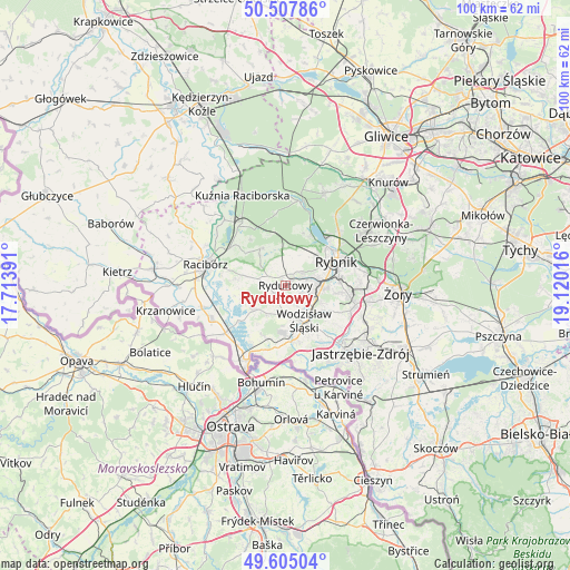
Rydułtowy GPS coordinates[2]
50° 3' 30.852" North, 18° 25' 1.308" East
| Map corner | latitude | longitude |
|---|---|---|
| Upper-left | 50.50786°, | 17.71391° |
| Center: | 50.05857°, | 18.41703° |
| Lower-right: | 49.60504°, | 19.12016° |
| Map W x H: | 100.4×100.4 km | = 62.4×62.4mi |
| max Lat: | 54.83135° ⇑79.7% North |
| Rydułtowy: | 50.05857° |
| min Lat: | ⇓20.3% South 49.21328° |
| min Long | Rydułtowy | max Long |
| 14.20249° | 18.41703° | 24.03723° |
| W 30.6%⇐ | ⇒69.4% E |
Elevation
Elevation of Rydułtowy is 284 m = 932 ft, and this is 92.6 m = 304 ft above average elevation for this country.
| Max E: |
974 m = 3196 ft | 16.3% |
| Rydułtowy | 284 m 932 ft | |
| Avg. | 191.4 m = 628 ft | |
Min E: |
-3 m = -10 ft | 83.7% |
See also: Poland elevation on elevation.city.
Geographical zone
Rydułtowy is located in North temperate zone (between Tropic of Cancer and the Arctic Circle). Distance of this North polar circle is 1835.2 km =1140.3 mi to North.| Distance of | km | miles | from Rydułtowy |
|---|---|---|---|
| North Pole | 4441.1 | 2759.6 | to North |
| Arctic Circle | 1835.2 | 1140.3 | to North |
| Tropic Cancer | 2960.1 | 1839.3 | to South |
| Equator | 5566 | 3458.6 | to South |


Nearby cities:
15 places around Rydułtowy: (largest is in red/bold)
• Czernica
3 km =1.9 mi,  337°
337°
• Czyżowice
8.2 km =5.1 mi,  186°
186°
• Gaszowice
5.6 km =3.5 mi,  9°
9°
• Jejkowice
6.6 km =4.1 mi,  33°
33°
• Kornowac
6.5 km =4 mi,  283°
283°
• Lubomia
8 km =5 mi,  254°
254°
• Lyski
7.1 km =4.4 mi,  345°
345°
• Niedobczyce
5.6 km =3.5 mi,  82°
82°
• Pogrzebień
8.5 km =5.3 mi, 276°
• Pszów
2.6 km =1.6 mi,  217°
217°
• Radlin
4.3 km =2.7 mi,  102°
102°
• Syrynia
6.6 km =4.1 mi,  229°
229°
• Szczerbice
4.6 km =2.9 mi, 29°
• Wodzisław Śląski
7.3 km =4.5 mi,  147°
147°
• Zebrzydowice
7.5 km =4.7 mi,  52°
52°
Sources, notices
• [Note1] Compared only with cities in Poland existing in our database
• [Src1] Map data: © OpenStreetMap contributors (CC-BY-SA)
• [Src2] Other city data from geonames.org with taken over terms of usage.
• [Src3] Geographical zone / Annual Mean Temperature by Robert A. Rohde @ Wikipedia
