Pszów geodata
Pszów (Silesia) is a seat of a third-order administrative division; located in Poland in Europe/Warsaw (GMT+2) time zone. With population of 14,028 people, there are 353 cities with bigger population in this country. Compared to other cities in Poland, 80.5% of cities are located further ↑North; 69.8% of cities are located further →East and 86.9% of cities have lower elevation than Pszów. Note1


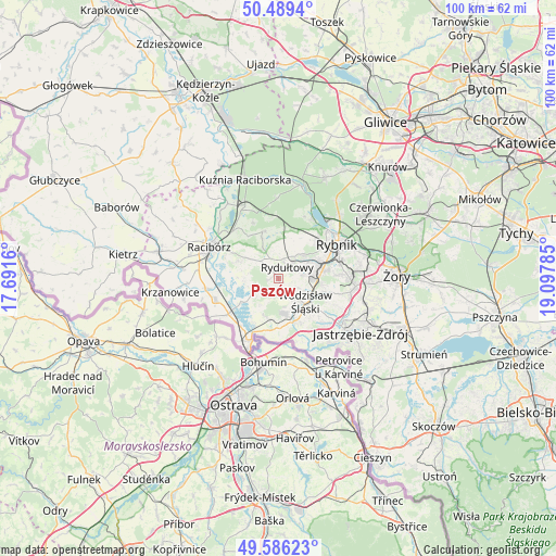
Pszów GPS coordinates[2]
50° 2' 23.784" North, 18° 23' 40.992" East
| Map corner | latitude | longitude |
|---|---|---|
| Upper-left | 50.4894°, | 17.6916° |
| Center: | 50.03994°, | 18.39472° |
| Lower-right: | 49.58623°, | 19.09785° |
| Map W x H: | 100.4×100.4 km | = 62.4×62.4mi |
| max Lat: | 54.83135° ⇑80.5% North |
| Pszów: | 50.03994° |
| min Lat: | ⇓19.5% South 49.21328° |
| min Long | Pszów | max Long |
| 14.20249° | 18.39472° | 24.03723° |
| W 30.2%⇐ | ⇒69.8% E |
Elevation
Elevation of Pszów is 300 m = 984 ft, and this is 108.6 m = 356 ft above average elevation for this country.
| Max E: |
974 m = 3196 ft | 13.1% |
| Pszów | 300 m 984 ft | |
| Avg. | 191.4 m = 628 ft | |
Min E: |
-3 m = -10 ft | 86.9% |
See also: Poland elevation on elevation.city.
Geographical zone
Pszów is located in North temperate zone (between Tropic of Cancer and the Arctic Circle). Distance of this North polar circle is 1837.3 km =1141.6 mi to North.| Distance of | km | miles | from Pszów |
|---|---|---|---|
| North Pole | 4443.1 | 2760.8 | to North |
| Arctic Circle | 1837.3 | 1141.6 | to North |
| Tropic Cancer | 2958 | 1838 | to South |
| Equator | 5563.9 | 3457.2 | to South |


Nearby cities:
15 places around Pszów: (largest is in red/bold)
• Bełsznica
7.2 km =4.5 mi,  198°
198°
• Czernica
4.9 km =3 mi,  4°
4°
• Czyżowice
6.2 km =3.9 mi,  173°
173°
• Gaszowice
8 km =5 mi,  18°
18°
• Kornowac
5.9 km =3.7 mi,  306°
306°
• Lubomia
6.2 km =3.9 mi,  269°
269°
• Niedobczyce
7.7 km =4.8 mi,  68°
68°
• Pogrzebień
7.5 km =4.7 mi,  293°
293°
• Radlin
5.9 km =3.7 mi,  78°
78°
• Rogów
6.3 km =3.9 mi,  209°
209°
• Rydułtowy
2.6 km =1.6 mi,  37°
37°
• Syrynia
4.1 km =2.5 mi,  237°
237°
• Szczerbice
7.2 km =4.5 mi,  32°
32°
• Turza Śląska
8.1 km =5 mi,  157°
157°
• Wodzisław Śląski
6.8 km =4.2 mi,  126°
126°
Sources, notices
• [Note1] Compared only with cities in Poland existing in our database
• [Src1] Map data: © OpenStreetMap contributors (CC-BY-SA)
• [Src2] Other city data from geonames.org with taken over terms of usage.
• [Src3] Geographical zone / Annual Mean Temperature by Robert A. Rohde @ Wikipedia
