Radlin geodata
Radlin (Silesia) is a seat of a third-order administrative division; located in Poland in Europe/Warsaw (GMT+2) time zone. With population of 17,479 people, there are 285 cities with bigger population in this country. Compared to other cities in Poland, 80.1% of cities are located further ↑North; 68.6% of cities are located further →East and 84.4% of cities have lower elevation than Radlin. Note1


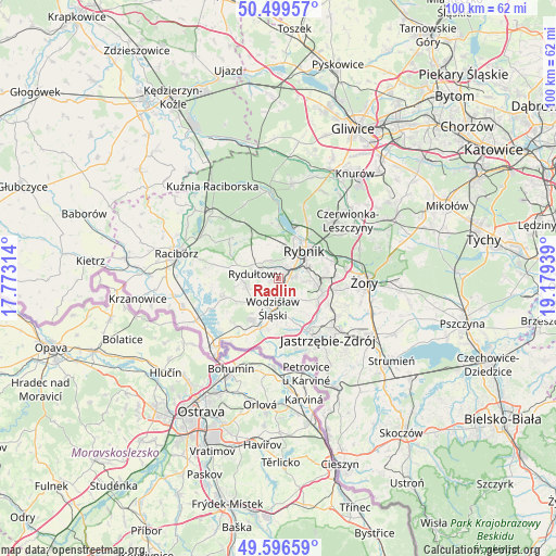
Radlin GPS coordinates[2]
50° 3' 0.72" North, 18° 28' 34.536" East
| Map corner | latitude | longitude |
|---|---|---|
| Upper-left | 50.49957°, | 17.77314° |
| Center: | 50.0502°, | 18.47626° |
| Lower-right: | 49.59659°, | 19.17939° |
| Map W x H: | 100.4×100.4 km | = 62.4×62.4mi |
| max Lat: | 54.83135° ⇑80.1% North |
| Radlin: | 50.0502° |
| min Lat: | ⇓19.9% South 49.21328° |
| min Long | Radlin | max Long |
| 14.20249° | 18.47626° | 24.03723° |
| W 31.4%⇐ | ⇒68.6% E |
Elevation
Elevation of Radlin is 287 m = 942 ft, and this is 95.6 m = 314 ft above average elevation for this country.
| Max E: |
974 m = 3196 ft | 15.6% |
| Radlin | 287 m 942 ft | |
| Avg. | 191.4 m = 628 ft | |
Min E: |
-3 m = -10 ft | 84.4% |
See also: Poland elevation on elevation.city.
Geographical zone
Radlin is located in North temperate zone (between Tropic of Cancer and the Arctic Circle). Distance of this North polar circle is 1836.1 km =1140.9 mi to North.| Distance of | km | miles | from Radlin |
|---|---|---|---|
| North Pole | 4442 | 2760.1 | to North |
| Arctic Circle | 1836.1 | 1140.9 | to North |
| Tropic Cancer | 2959.1 | 1838.7 | to South |
| Equator | 5565.1 | 3458 | to South |


Nearby cities:
15 places around Radlin: (largest is in red/bold)
• Czernica
6.6 km =4.1 mi,  304°
304°
• Gaszowice
7.3 km =4.5 mi,  333°
333°
• Jankowice Rybnickie
5.1 km =3.2 mi,  96°
96°
• Jejkowice
6.5 km =4 mi,  354°
354°
• Markłowice
4.9 km =3 mi,  139°
139°
• Niedobczyce
2.2 km =1.4 mi,  38°
38°
• Połomia
8.4 km =5.2 mi, 140°
• Pszów
5.9 km =3.7 mi,  258°
258°
• Rybnik
7 km =4.3 mi, 41°
• Rydułtowy
4.3 km =2.7 mi,  282°
282°
• Szczerbice
5.3 km =3.3 mi,  338°
338°
• Wodzisław Śląski
5.2 km =3.2 mi,  183°
183°
• Zebrzydowice
5.8 km =3.6 mi,  17°
17°
• Świerklany Dolne
8 km =5 mi,  116°
116°
• Świerklany Górne
8.5 km =5.3 mi,  107°
107°
Sources, notices
• [Note1] Compared only with cities in Poland existing in our database
• [Src1] Map data: © OpenStreetMap contributors (CC-BY-SA)
• [Src2] Other city data from geonames.org with taken over terms of usage.
• [Src3] Geographical zone / Annual Mean Temperature by Robert A. Rohde @ Wikipedia
