Rybno geodata
Rybno (Greater Poland) is a populated place; located in Poland in Europe/Warsaw (GMT+2) time zone. With population of 860 people, there are 2749 cities with bigger population in this country. Compared to other cities in Poland, 78.1% of cities are located further ↓South; 81.5% of cities are located further →East and 76.9% of cities have higher elevation than Rybno. Note1


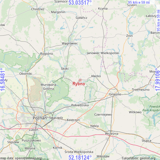
Rybno GPS coordinates[2]
52° 36' 37.044" North, 17° 17' 16.548" East
| Map corner | latitude | longitude |
|---|---|---|
| Upper-left | 53.03517°, | 16.58481° |
| Center: | 52.61029°, | 17.28793° |
| Lower-right: | 52.18124°, | 17.99106° |
| Map W x H: | 94.9×94.9 km | = 59×59mi |
| max Lat: | 54.83135° ⇑21.9% North |
| Rybno: | 52.61029° |
| min Lat: | ⇓78.1% South 49.21328° |
| min Long | Rybno | max Long |
| 14.20249° | 17.28793° | 24.03723° |
| W 18.5%⇐ | ⇒81.5% E |
Elevation
Elevation of Rybno is 106 m = 348 ft, and this is 85.4 m = 280 ft below average elevation for this country.
| Max E: |
974 m = 3196 ft | 76.9% |
| Avg. | 191.4 m = 628 ft | |
| Rybno | 106 m = 348 ft | |
Min E: |
-3 m = -10 ft | 23.1% |
See also: Poland elevation on elevation.city.
Geographical zone
Rybno is located in North temperate zone (between Tropic of Cancer and the Arctic Circle). Distance of this North polar circle is 1551.5 km =964.1 mi to North.| Distance of | km | miles | from Rybno |
|---|---|---|---|
| North Pole | 4157.3 | 2583.2 | to North |
| Arctic Circle | 1551.5 | 964.1 | to North |
| Tropic Cancer | 3243.8 | 2015.6 | to South |
| Equator | 5849.7 | 3634.8 | to South |


Nearby cities:
15 places around Rybno: (largest is in red/bold)
• Czerniejewo
24.6 km =15.3 mi,  146°
146°
• Gniezno
21.6 km =13.4 mi,  112°
112°
• Janowiec Wielkopolski
21.1 km =13.1 mi,  40°
40°
• Kiszkowo
2.8 km =1.7 mi,  211°
211°
• Kobylnica
23.2 km =14.4 mi,  218°
218°
• Kostrzyn
23.9 km =14.9 mi,  189°
189°
• Kłecko
9.9 km =6.2 mi,  76°
76°
• Mieleszyn
15.6 km =9.7 mi,  65°
65°
• Mieścisko
15.1 km =9.4 mi,  11°
11°
• Murowana Goślina
19.2 km =11.9 mi,  258°
258°
• Pobiedziska
14.8 km =9.2 mi,  180°
180°
• Rogoźno
25.5 km =15.8 mi,  308°
308°
• Skoki
11 km =6.8 mi, 308°
• Wągrowiec
22.8 km =14.2 mi,  344°
344°
• Łubowo
15.7 km =9.8 mi,  134°
134°
Sources, notices
• [Note1] Compared only with cities in Poland existing in our database
• [Src1] Map data: © OpenStreetMap contributors (CC-BY-SA)
• [Src2] Other city data from geonames.org with taken over terms of usage.
• [Src3] Geographical zone / Annual Mean Temperature by Robert A. Rohde @ Wikipedia
