Łubowo geodata
Łubowo (Greater Poland) is a seat of a third-order administrative division; located in Poland in Europe/Warsaw (GMT+2) time zone. With population of 951 people, there are 2590 cities with bigger population in this country. Compared to other cities in Poland, 76.7% of cities are located further ↓South; 80.4% of cities are located further →East and 73.1% of cities have higher elevation than Łubowo. Note1


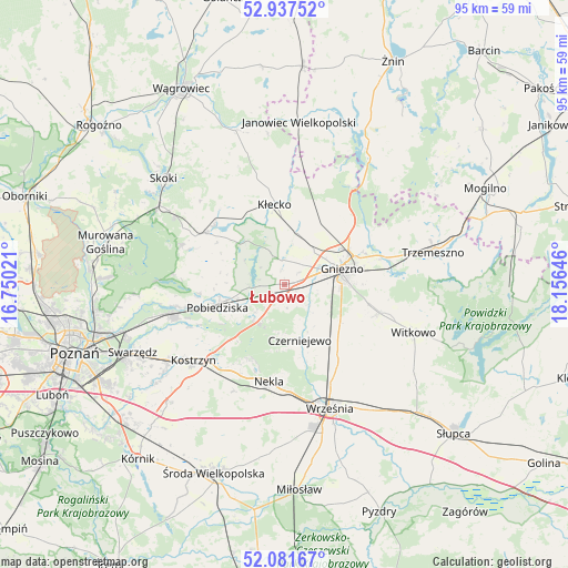
Łubowo GPS coordinates[2]
52° 30' 42.048" North, 17° 27' 11.988" East
| Map corner | latitude | longitude |
|---|---|---|
| Upper-left | 52.93752°, | 16.75021° |
| Center: | 52.51168°, | 17.45333° |
| Lower-right: | 52.08167°, | 18.15646° |
| Map W x H: | 95.2×95.2 km | = 59.2×59.2mi |
| max Lat: | 54.83135° ⇑23.3% North |
| Łubowo: | 52.51168° |
| min Lat: | ⇓76.7% South 49.21328° |
| min Long | Łubowo | max Long |
| 14.20249° | 17.45333° | 24.03723° |
| W 19.6%⇐ | ⇒80.4% E |
Elevation
Elevation of Łubowo is 115 m = 377 ft, and this is 76.4 m = 251 ft below average elevation for this country.
| Max E: |
974 m = 3196 ft | 73.1% |
| Avg. | 191.4 m = 628 ft | |
| Łubowo | 115 m = 377 ft | |
Min E: |
-3 m = -10 ft | 26.9% |
See also: Poland elevation on elevation.city.
Geographical zone
Łubowo is located in North temperate zone (between Tropic of Cancer and the Arctic Circle). Distance of this North polar circle is 1562.4 km =970.8 mi to North.| Distance of | km | miles | from Łubowo |
|---|---|---|---|
| North Pole | 4168.3 | 2590.1 | to North |
| Arctic Circle | 1562.4 | 970.8 | to North |
| Tropic Cancer | 3232.8 | 2008.8 | to South |
| Equator | 5838.8 | 3628.1 | to South |


Nearby cities:
15 places around Łubowo: (largest is in red/bold)
• Czerniejewo
9.8 km =6.1 mi,  165°
165°
• Dominowo
25.3 km =15.7 mi,  194°
194°
• Gniezno
9.1 km =5.7 mi,  73°
73°
• Kiszkowo
15.3 km =9.5 mi,  304°
304°
• Kobylnica
26.5 km =16.5 mi,  254°
254°
• Kostrzyn
19.8 km =12.3 mi,  230°
230°
• Kłecko
13.4 km =8.3 mi,  353°
353°
• Mieleszyn
17.7 km =11 mi,  9°
9°
• Nekla
16.5 km =10.3 mi, 189°
• Niechanowo
16.1 km =10 mi,  108°
108°
• Pobiedziska
11.8 km =7.3 mi, 251°
• Rybno
15.7 km =9.8 mi,  314°
314°
• Trzemeszno
25.6 km =15.9 mi,  77°
77°
• Witkowo
23.1 km =14.4 mi, 110°
• Września
22.1 km =13.7 mi,  159°
159°
Sources, notices
• [Note1] Compared only with cities in Poland existing in our database
• [Src1] Map data: © OpenStreetMap contributors (CC-BY-SA)
• [Src2] Other city data from geonames.org with taken over terms of usage.
• [Src3] Geographical zone / Annual Mean Temperature by Robert A. Rohde @ Wikipedia
