Kostrzyn geodata
Kostrzyn (Greater Poland) is a seat of a third-order administrative division; located in Poland in Europe/Warsaw (GMT+2) time zone. With population of 8,965 people, there are 481 cities with bigger population in this country. Compared to other cities in Poland, 74.6% of cities are located further ↓South; 82% of cities are located further →East and 79.3% of cities have higher elevation than Kostrzyn. Note1


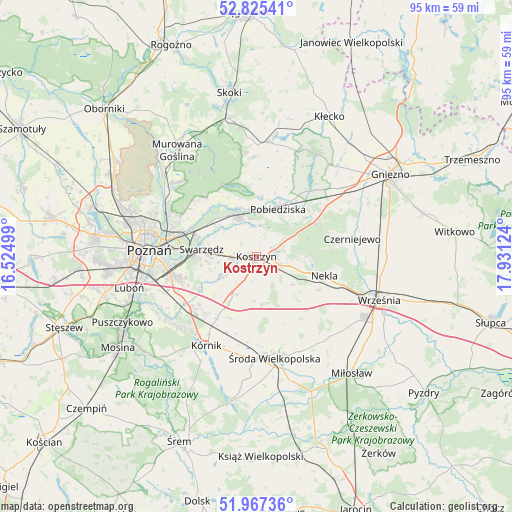
Kostrzyn GPS coordinates[2]
52° 23' 54.492" North, 17° 13' 41.196" East
| Map corner | latitude | longitude |
|---|---|---|
| Upper-left | 52.82541°, | 16.52499° |
| Center: | 52.39847°, | 17.22811° |
| Lower-right: | 51.96736°, | 17.93124° |
| Map W x H: | 95.4×95.4 km | = 59.3×59.3mi |
| max Lat: | 54.83135° ⇑25.4% North |
| Kostrzyn: | 52.39847° |
| min Lat: | ⇓74.6% South 49.21328° |
| min Long | Kostrzyn | max Long |
| 14.20249° | 17.22811° | 24.03723° |
| W 18%⇐ | ⇒82% E |
Elevation
Elevation of Kostrzyn is 101 m = 331 ft, and this is 90.4 m = 297 ft below average elevation for this country.
| Max E: |
974 m = 3196 ft | 79.3% |
| Avg. | 191.4 m = 628 ft | |
| Kostrzyn | 101 m = 331 ft | |
Min E: |
-3 m = -10 ft | 20.7% |
See also: Poland elevation on elevation.city.
Geographical zone
Kostrzyn is located in North temperate zone (between Tropic of Cancer and the Arctic Circle). Distance of this North polar circle is 1575 km =978.7 mi to North.| Distance of | km | miles | from Kostrzyn |
|---|---|---|---|
| North Pole | 4180.9 | 2597.9 | to North |
| Arctic Circle | 1575 | 978.7 | to North |
| Tropic Cancer | 3220.2 | 2000.9 | to South |
| Equator | 5826.2 | 3620.2 | to South |


Nearby cities:
15 places around Kostrzyn: (largest is in red/bold)
• Czerniejewo
18 km =11.2 mi,  80°
80°
• Czerwonak
18.3 km =11.4 mi,  293°
293°
• Dominowo
14.8 km =9.2 mi,  143°
143°
• Gądki
15.6 km =9.7 mi,  231°
231°
• Kiszkowo
21.3 km =13.2 mi,  6°
6°
• Kleszczewo
8.2 km =5.1 mi,  208°
208°
• Kobylnica
11.6 km =7.2 mi,  297°
297°
• Kórnik
19.2 km =11.9 mi, 209°
• Nekla
13.1 km =8.1 mi,  106°
106°
• Pobiedziska
9.7 km =6 mi,  24°
24°
• Poznań
20.2 km =12.6 mi,  272°
272°
• Swarzędz
9.8 km =6.1 mi,  279°
279°
• Słupia Wiełka
20.1 km =12.5 mi,  181°
181°
• Łubowo
19.8 km =12.3 mi,  50°
50°
• Środa Wielkopolska
19.2 km =11.9 mi,  170°
170°
Sources, notices
• [Note1] Compared only with cities in Poland existing in our database
• [Src1] Map data: © OpenStreetMap contributors (CC-BY-SA)
• [Src2] Other city data from geonames.org with taken over terms of usage.
• [Src3] Geographical zone / Annual Mean Temperature by Robert A. Rohde @ Wikipedia
