Kobylnica geodata
Kobylnica (Greater Poland) is a populated place; located in Poland in Europe/Warsaw (GMT+2) time zone. With population of 1,480 people, there are 1891 cities with bigger population in this country. Compared to other cities in Poland, 75.6% of cities are located further ↓South; 83.5% of cities are located further →East and 85.2% of cities have higher elevation than Kobylnica. Note1


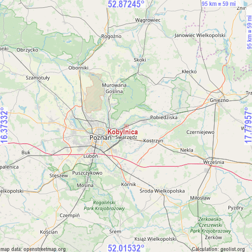
Kobylnica GPS coordinates[2]
52° 26' 45.492" North, 17° 4' 35.184" East
| Map corner | latitude | longitude |
|---|---|---|
| Upper-left | 52.87245°, | 16.37332° |
| Center: | 52.44597°, | 17.07644° |
| Lower-right: | 52.01532°, | 17.77957° |
| Map W x H: | 95.3×95.3 km | = 59.2×59.2mi |
| max Lat: | 54.83135° ⇑24.4% North |
| Kobylnica: | 52.44597° |
| min Lat: | ⇓75.6% South 49.21328° |
| min Long | Kobylnica | max Long |
| 14.20249° | 17.07644° | 24.03723° |
| W 16.5%⇐ | ⇒83.5% E |
Elevation
Elevation of Kobylnica is 89 m = 292 ft, and this is 102.4 m = 336 ft below average elevation for this country.
| Max E: |
974 m = 3196 ft | 85.2% |
| Avg. | 191.4 m = 628 ft | |
| Kobylnica | 89 m = 292 ft | |
Min E: |
-3 m = -10 ft | 14.8% |
See also: Poland elevation on elevation.city.
Geographical zone
Kobylnica is located in North temperate zone (between Tropic of Cancer and the Arctic Circle). Distance of this North polar circle is 1569.7 km =975.4 mi to North.| Distance of | km | miles | from Kobylnica |
|---|---|---|---|
| North Pole | 4175.6 | 2594.6 | to North |
| Arctic Circle | 1569.7 | 975.4 | to North |
| Tropic Cancer | 3225.5 | 2004.2 | to South |
| Equator | 5831.4 | 3623.5 | to South |


Nearby cities:
15 places around Kobylnica: (largest is in red/bold)
• Baranowo
19.7 km =12.2 mi,  266°
266°
• Czapury
18.1 km =11.2 mi,  217°
217°
• Czerwonak
6.7 km =4.2 mi,  287°
287°
• Daszewice
18.1 km =11.2 mi,  206°
206°
• Gądki
15 km =9.3 mi,  187°
187°
• Kleszczewo
14 km =8.7 mi,  152°
152°
• Kostrzyn
11.6 km =7.2 mi,  117°
117°
• Luboń
16.6 km =10.3 mi,  228°
228°
• Murowana Goślina
15 km =9.3 mi,  342°
342°
• Pobiedziska
14.7 km =9.1 mi,  76°
76°
• Poznań
10.8 km =6.7 mi,  246°
246°
• Suchy Las
13.8 km =8.6 mi,  282°
282°
• Swarzędz
3.7 km =2.3 mi,  171°
171°
• Wiórek
19.5 km =12.1 mi, 215°
• Złotniki
16.6 km =10.3 mi, 288°
Sources, notices
• [Note1] Compared only with cities in Poland existing in our database
• [Src1] Map data: © OpenStreetMap contributors (CC-BY-SA)
• [Src2] Other city data from geonames.org with taken over terms of usage.
• [Src3] Geographical zone / Annual Mean Temperature by Robert A. Rohde @ Wikipedia
