Pobiedziska geodata
Pobiedziska (Greater Poland) is a seat of a third-order administrative division; located in Poland in Europe/Warsaw (GMT+2) time zone. With population of 8,677 people, there are 491 cities with bigger population in this country. Compared to other cities in Poland, 76.1% of cities are located further ↓South; 81.5% of cities are located further →East and 75.8% of cities have higher elevation than Pobiedziska. Note1


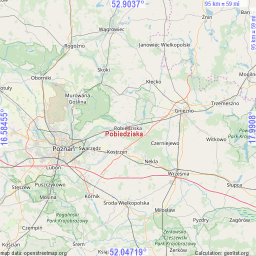
Pobiedziska GPS coordinates[2]
52° 28' 39.108" North, 17° 17' 15.612" East
| Map corner | latitude | longitude |
|---|---|---|
| Upper-left | 52.9037°, | 16.58455° |
| Center: | 52.47753°, | 17.28767° |
| Lower-right: | 52.04719°, | 17.9908° |
| Map W x H: | 95.2×95.2 km | = 59.2×59.2mi |
| max Lat: | 54.83135° ⇑23.9% North |
| Pobiedziska: | 52.47753° |
| min Lat: | ⇓76.1% South 49.21328° |
| min Long | Pobiedziska | max Long |
| 14.20249° | 17.28767° | 24.03723° |
| W 18.5%⇐ | ⇒81.5% E |
Elevation
Elevation of Pobiedziska is 109 m = 358 ft, and this is 82.4 m = 270 ft below average elevation for this country.
| Max E: |
974 m = 3196 ft | 75.8% |
| Avg. | 191.4 m = 628 ft | |
| Pobiedziska | 109 m = 358 ft | |
Min E: |
-3 m = -10 ft | 24.2% |
See also: Poland elevation on elevation.city.
Geographical zone
Pobiedziska is located in North temperate zone (between Tropic of Cancer and the Arctic Circle). Distance of this North polar circle is 1566.2 km =973.2 mi to North.| Distance of | km | miles | from Pobiedziska |
|---|---|---|---|
| North Pole | 4172.1 | 2592.4 | to North |
| Arctic Circle | 1566.2 | 973.2 | to North |
| Tropic Cancer | 3229 | 2006.4 | to South |
| Equator | 5835 | 3625.7 | to South |


Nearby cities:
15 places around Pobiedziska: (largest is in red/bold)
• Czerniejewo
14.8 km =9.2 mi,  112°
112°
• Czerwonak
20.8 km =12.9 mi,  266°
266°
• Dominowo
21.2 km =13.2 mi,  167°
167°
• Gniezno
21 km =13 mi,  72°
72°
• Kiszkowo
12.4 km =7.7 mi,  353°
353°
• Kleszczewo
17.8 km =11.1 mi,  206°
206°
• Kobylnica
14.7 km =9.1 mi,  256°
256°
• Kostrzyn
9.7 km =6 mi,  204°
204°
• Kłecko
19.7 km =12.2 mi,  29°
29°
• Murowana Goślina
21.7 km =13.5 mi,  299°
299°
• Nekla
15.1 km =9.4 mi,  145°
145°
• Rybno
14.8 km =9.2 mi,  0°
0°
• Skoki
23.3 km =14.5 mi,  338°
338°
• Swarzędz
15.5 km =9.6 mi,  242°
242°
• Łubowo
11.8 km =7.3 mi, 71°
Sources, notices
• [Note1] Compared only with cities in Poland existing in our database
• [Src1] Map data: © OpenStreetMap contributors (CC-BY-SA)
• [Src2] Other city data from geonames.org with taken over terms of usage.
• [Src3] Geographical zone / Annual Mean Temperature by Robert A. Rohde @ Wikipedia
