Janowiec Wielkopolski geodata
Janowiec Wielkopolski (Kujawsko-Pomorskie) is a seat of a third-order administrative division; located in Poland in Europe/Warsaw (GMT+2) time zone. With population of 5,110 people, there are 678 cities with bigger population in this country. Compared to other cities in Poland, 80.2% of cities are located further ↓South; 80% of cities are located further →East and 81.2% of cities have higher elevation than Janowiec Wielkopolski. Note1
Administrative division(s):
- Level 1: Kujawsko-Pomorskie
- Level 2: Powiat żniński
- Level 3: Janowiec Wielkopolski
Current local time in Janowiec Wielkopolski:
05:22 AM, SaturdayDifference from your time zone: hours


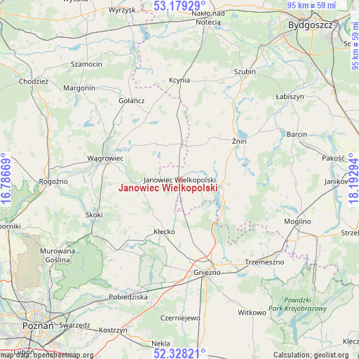
Janowiec Wielkopolski GPS coordinates[2]
52° 45' 20.988" North, 17° 29' 23.316" East
| Map corner | latitude | longitude |
|---|---|---|
| Upper-left | 53.17929°, | 16.78669° |
| Center: | 52.75583°, | 17.48981° |
| Lower-right: | 52.32821°, | 18.19294° |
| Map W x H: | 94.6×94.6 km | = 58.8×58.8mi |
| max Lat: | 54.83135° ⇑19.8% North |
| Janowiec Wielkopolski: | 52.75583° |
| min Lat: | ⇓80.2% South 49.21328° |
| min Long | Janowiec Wielko | max Long |
| 14.20249° | 17.48981° | 24.03723° |
| W 20%⇐ | ⇒80% E |
Elevation
Elevation of Janowiec Wielkopolski is 97 m = 318 ft, and this is 94.4 m = 310 ft below average elevation for this country.
| Max E: |
974 m = 3196 ft | 81.2% |
| Avg. | 191.4 m = 628 ft | |
| Janowiec Wielkopolski | 97 m = 318 ft | |
Min E: |
-3 m = -10 ft | 18.8% |
See also: Poland elevation on elevation.city.
Geographical zone
Janowiec Wielkopolski is located in North temperate zone (between Tropic of Cancer and the Arctic Circle). Distance of this North polar circle is 1535.3 km =954 mi to North.| Distance of | km | miles | from Janowiec Wielkopolski |
|---|---|---|---|
| North Pole | 4141.2 | 2573.2 | to North |
| Arctic Circle | 1535.3 | 954 | to North |
| Tropic Cancer | 3260 | 2025.7 | to South |
| Equator | 5865.9 | 3644.9 | to South |


Nearby cities:
15 places around Janowiec Wielkopolski: (largest is in red/bold)
• Brzyskorzystewko
20.4 km =12.7 mi,  41°
41°
• Damasławek
9.4 km =5.8 mi,  4°
4°
• Gąsawa
17.9 km =11.1 mi,  85°
85°
• Kiszkowo
23.9 km =14.9 mi,  219°
219°
• Królikowo
24.4 km =15.2 mi,  21°
21°
• Kłecko
14.4 km =8.9 mi,  196°
196°
• Mieleszyn
9.7 km =6 mi,  176°
176°
• Mieścisko
10.7 km =6.6 mi,  262°
262°
• Rogowo
11.4 km =7.1 mi,  107°
107°
• Rybno
21.1 km =13.1 mi, 220°
• Sarbinowo
16 km =9.9 mi,  48°
48°
• Skoki
24 km =14.9 mi,  247°
247°
• Wapno
17 km =10.6 mi,  356°
356°
• Wągrowiec
20.4 km =12.7 mi,  286°
286°
• Żnin
18.7 km =11.6 mi,  56°
56°
Sources, notices
• [Note1] Compared only with cities in Poland existing in our database
• [Src1] Map data: © OpenStreetMap contributors (CC-BY-SA)
• [Src2] Other city data from geonames.org with taken over terms of usage.
• [Src3] Geographical zone / Annual Mean Temperature by Robert A. Rohde @ Wikipedia
