Rokitno Szlacheckie geodata
Rokitno Szlacheckie (Silesia) is a populated place; located in Poland in Europe/Warsaw (GMT+2) time zone. With population of 1,094 people, there are 2364 cities with bigger population in this country. Compared to other cities in Poland, 68.8% of cities are located further ↑North; 52.2% of cities are located further →East and 91.8% of cities have lower elevation than Rokitno Szlacheckie. Note1


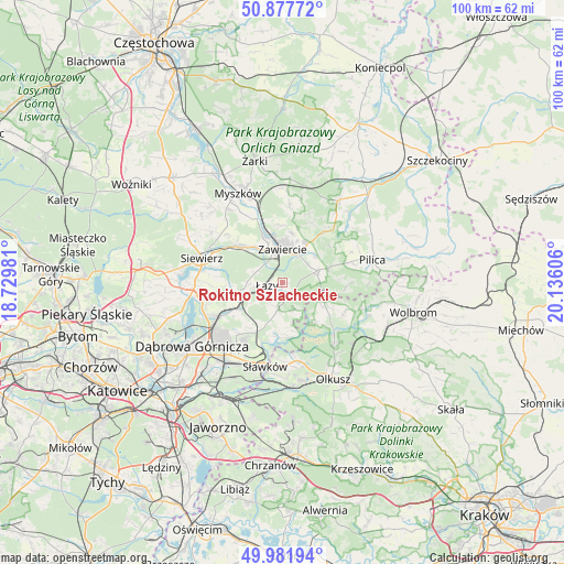
Rokitno Szlacheckie GPS coordinates[2]
50° 25' 55.02" North, 19° 25' 58.548" East
| Map corner | latitude | longitude |
|---|---|---|
| Upper-left | 50.87772°, | 18.72981° |
| Center: | 50.43195°, | 19.43293° |
| Lower-right: | 49.98194°, | 20.13606° |
| Map W x H: | 99.6×99.6 km | = 61.9×61.9mi |
| max Lat: | 54.83135° ⇑68.8% North |
| Rokitno Szlacheckie: | 50.43195° |
| min Lat: | ⇓31.2% South 49.21328° |
| min Long | Rokitno Szlache | max Long |
| 14.20249° | 19.43293° | 24.03723° |
| W 47.8%⇐ | ⇒52.2% E |
Elevation
Elevation of Rokitno Szlacheckie is 354 m = 1161 ft, and this is 162.6 m = 533 ft above average elevation for this country.
| Max E: |
974 m = 3196 ft | 8.2% |
| Rokitno Szlacheckie | 354 m 1161 ft | |
| Avg. | 191.4 m = 628 ft | |
Min E: |
-3 m = -10 ft | 91.8% |
See also: Poland elevation on elevation.city.
Geographical zone
Rokitno Szlacheckie is located in North temperate zone (between Tropic of Cancer and the Arctic Circle). Distance of this North polar circle is 1793.7 km =1114.6 mi to North.| Distance of | km | miles | from Rokitno Szlacheckie |
|---|---|---|---|
| North Pole | 4399.6 | 2733.8 | to North |
| Arctic Circle | 1793.7 | 1114.6 | to North |
| Tropic Cancer | 3001.6 | 1865.1 | to South |
| Equator | 5607.5 | 3484.3 | to South |


Nearby cities:
15 places around Rokitno Szlacheckie: (largest is in red/bold)
• Bolesław
15.4 km =9.6 mi,  167°
167°
• Chruszczobród
7.7 km =4.8 mi,  255°
255°
• Ciągowice
5.1 km =3.2 mi,  289°
289°
• Klucze
14.1 km =8.8 mi,  139°
139°
• Krzykawka
13.3 km =8.3 mi,  183°
183°
• Niegowonice
4.8 km =3 mi,  188°
188°
• Ogrodzieniec
6.5 km =4 mi,  70°
70°
• Poręba
9.1 km =5.7 mi,  313°
313°
• Rudniki
9.9 km =6.2 mi,  359°
359°
• Siewierz
14.9 km =9.3 mi, 285°
• Sławków
15.1 km =9.4 mi, 191°
• Wysoka
5.6 km =3.5 mi,  267°
267°
• Włodowice
13.8 km =8.6 mi,  5°
5°
• Zawiercie
6.3 km =3.9 mi,  349°
349°
• Łazy
2.8 km =1.7 mi, 260°
Sources, notices
• [Note1] Compared only with cities in Poland existing in our database
• [Src1] Map data: © OpenStreetMap contributors (CC-BY-SA)
• [Src2] Other city data from geonames.org with taken over terms of usage.
• [Src3] Geographical zone / Annual Mean Temperature by Robert A. Rohde @ Wikipedia
