Głogoczów geodata
Głogoczów (Lesser Poland) is a populated place; located in Poland in Europe/Warsaw (GMT+2) time zone. With population of 2,800 people, there are 1120 cities with bigger population in this country. Compared to other cities in Poland, 87.8% of cities are located further ↑North; 56.4% of cities are located further ←West and 72.4% of cities have lower elevation than Głogoczów. Note1


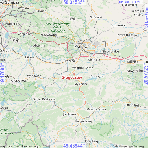
Głogoczów GPS coordinates[2]
49° 53' 40.272" North, 19° 52' 26.76" East
| Map corner | latitude | longitude |
|---|---|---|
| Upper-left | 50.34535°, | 19.17098° |
| Center: | 49.89452°, | 19.8741° |
| Lower-right: | 49.43944°, | 20.57723° |
| Map W x H: | 100.7×100.7 km | = 62.6×62.6mi |
| max Lat: | 54.83135° ⇑87.8% North |
| Głogoczów: | 49.89452° |
| min Lat: | ⇓12.2% South 49.21328° |
| min Long | Głogoczów | max Long |
| 14.20249° | 19.8741° | 24.03723° |
| W 56.4%⇐ | ⇒43.6% E |
Elevation
Elevation of Głogoczów is 237 m = 778 ft, and this is 45.6 m = 150 ft above average elevation for this country.
| Max E: |
974 m = 3196 ft | 27.6% |
| Głogoczów | 237 m 778 ft | |
| Avg. | 191.4 m = 628 ft | |
Min E: |
-3 m = -10 ft | 72.4% |
See also: Poland elevation on elevation.city.
Geographical zone
Głogoczów is located in North temperate zone (between Tropic of Cancer and the Arctic Circle). Distance of this North polar circle is 1853.4 km =1151.6 mi to North.| Distance of | km | miles | from Głogoczów |
|---|---|---|---|
| North Pole | 4459.3 | 2770.9 | to North |
| Arctic Circle | 1853.4 | 1151.6 | to North |
| Tropic Cancer | 2941.8 | 1827.9 | to South |
| Equator | 5547.8 | 3447.2 | to South |


Nearby cities:
15 places around Głogoczów: (largest is in red/bold)
• Biertowice
6.3 km =3.9 mi,  246°
246°
• Buków
6.1 km =3.8 mi,  340°
340°
• Bęczarka
1.9 km =1.2 mi,  194°
194°
• Jawornik
4.5 km =2.8 mi,  162°
162°
• Konary
6.5 km =4 mi,  31°
31°
• Krzyszkowice
3.7 km =2.3 mi,  109°
109°
• Krzywaczka
3 km =1.9 mi,  267°
267°
• Mogilany
5.1 km =3.2 mi,  12°
12°
• Polanka
5.9 km =3.7 mi,  128°
128°
• Radziszów
6.2 km =3.9 mi,  317°
317°
• Rudnik
5.1 km =3.2 mi,  202°
202°
• Siepraw
6.4 km =4 mi,  69°
69°
• Sułkowice
8 km =5 mi,  221°
221°
• Wola Radziszowska
6.3 km =3.9 mi,  281°
281°
• Świątniki Górne
7.2 km =4.5 mi,  52°
52°
Sources, notices
• [Note1] Compared only with cities in Poland existing in our database
• [Src1] Map data: © OpenStreetMap contributors (CC-BY-SA)
• [Src2] Other city data from geonames.org with taken over terms of usage.
• [Src3] Geographical zone / Annual Mean Temperature by Robert A. Rohde @ Wikipedia
