Markłowice geodata
Markłowice (Silesia) is a seat of a third-order administrative division; located in Poland in Europe/Warsaw (GMT+2) time zone. With population of 5,173 people, there are 670 cities with bigger population in this country. Compared to other cities in Poland, 81.6% of cities are located further ↑North; 67.8% of cities are located further →East and 76.8% of cities have lower elevation than Markłowice. Note1


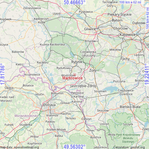
Markłowice GPS coordinates[2]
50° 1' 1.02" North, 18° 31' 15.528" East
| Map corner | latitude | longitude |
|---|---|---|
| Upper-left | 50.46663°, | 17.81786° |
| Center: | 50.01695°, | 18.52098° |
| Lower-right: | 49.56302°, | 19.22411° |
| Map W x H: | 100.5×100.5 km | = 62.4×62.4mi |
| max Lat: | 54.83135° ⇑81.6% North |
| Markłowice: | 50.01695° |
| min Lat: | ⇓18.4% South 49.21328° |
| min Long | Markłowice | max Long |
| 14.20249° | 18.52098° | 24.03723° |
| W 32.2%⇐ | ⇒67.8% E |
Elevation
Elevation of Markłowice is 253 m = 830 ft, and this is 61.6 m = 202 ft above average elevation for this country.
| Max E: |
974 m = 3196 ft | 23.2% |
| Markłowice | 253 m 830 ft | |
| Avg. | 191.4 m = 628 ft | |
Min E: |
-3 m = -10 ft | 76.8% |
See also: Poland elevation on elevation.city.
Geographical zone
Markłowice is located in North temperate zone (between Tropic of Cancer and the Arctic Circle). Distance of this North polar circle is 1839.8 km =1143.2 mi to North.| Distance of | km | miles | from Markłowice |
|---|---|---|---|
| North Pole | 4445.7 | 2762.4 | to North |
| Arctic Circle | 1839.8 | 1143.2 | to North |
| Tropic Cancer | 2955.4 | 1836.4 | to South |
| Equator | 5561.4 | 3455.7 | to South |


Nearby cities:
15 places around Markłowice: (largest is in red/bold)
• Czyżowice
9.1 km =5.7 mi,  246°
246°
• Gogołowa
6 km =3.7 mi,  124°
124°
• Jankowice Rybnickie
3.6 km =2.2 mi,  31°
31°
• Jastrzębie Zdrój
7.8 km =4.8 mi,  150°
150°
• Mszana
5.3 km =3.3 mi,  174°
174°
• Niedobczyce
5.7 km =3.5 mi,  341°
341°
• Połomia
3.5 km =2.2 mi,  142°
142°
• Radlin
4.9 km =3 mi,  319°
319°
• Rybnik
9 km =5.6 mi,  9°
9°
• Rydułtowy
8.7 km =5.4 mi,  301°
301°
• Skrzyszów
7.9 km =4.9 mi,  196°
196°
• Turza Śląska
7.7 km =4.8 mi,  230°
230°
• Wodzisław Śląski
3.8 km =2.4 mi, 247°
• Świerklany Dolne
4 km =2.5 mi,  87°
87°
• Świerklany Górne
5.1 km =3.2 mi,  76°
76°
Sources, notices
• [Note1] Compared only with cities in Poland existing in our database
• [Src1] Map data: © OpenStreetMap contributors (CC-BY-SA)
• [Src2] Other city data from geonames.org with taken over terms of usage.
• [Src3] Geographical zone / Annual Mean Temperature by Robert A. Rohde @ Wikipedia
