Puck geodata
Puck (Pomerania) is a seat of a second-order administrative division; located in Poland in Europe/Warsaw (GMT+2) time zone. With population of 11,415 people, there are 409 cities with bigger population in this country. Compared to other cities in Poland, 99.7% of cities are located further ↓South; 69.5% of cities are located further →East and 98.1% of cities have higher elevation than Puck. Note1


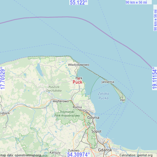
Puck GPS coordinates[2]
54° 43' 4.44" North, 18° 24' 30.276" East
| Map corner | latitude | longitude |
|---|---|---|
| Upper-left | 55.122°, | 17.70529° |
| Center: | 54.7179°, | 18.40841° |
| Lower-right: | 54.30974°, | 19.11154° |
| Map W x H: | 90.3×90.3 km | = 56.1×56.1mi |
| max Lat: | 54.83135° ⇑0.3% North |
| Puck: | 54.7179° |
| min Lat: | ⇓99.7% South 49.21328° |
| min Long | Puck | max Long |
| 14.20249° | 18.40841° | 24.03723° |
| W 30.5%⇐ | ⇒69.5% E |
Elevation
Elevation of Puck is 14 m = 46 ft, and this is 177.4 m = 582 ft below average elevation for this country.
| Max E: |
974 m = 3196 ft | 98.1% |
| Avg. | 191.4 m = 628 ft | |
| Puck | 14 m = 46 ft | |
Min E: |
-3 m = -10 ft | 1.9% |
See also: Poland elevation on elevation.city.
Geographical zone
Puck is located in North temperate zone (between Tropic of Cancer and the Arctic Circle). Distance of this North polar circle is 1317.1 km =818.4 mi to North.| Distance of | km | miles | from Puck |
|---|---|---|---|
| North Pole | 3923 | 2437.6 | to North |
| Arctic Circle | 1317.1 | 818.4 | to North |
| Tropic Cancer | 3478.1 | 2161.2 | to South |
| Equator | 6084.1 | 3780.5 | to South |


Nearby cities:
15 places around Puck: (largest is in red/bold)
• Chłapowo
9.8 km =6.1 mi,  346°
346°
• Dębogórze
14.5 km =9 mi,  167°
167°
• Gnieżdżewo
3.8 km =2.4 mi,  330°
330°
• Jastrzębia Góra
14 km =8.7 mi, 334°
• Kosakowo
15.1 km =9.4 mi,  161°
161°
• Mosty
13.1 km =8.1 mi,  154°
154°
• Mrzezino
7.3 km =4.5 mi, 168°
• Pierwoszyno
14.7 km =9.1 mi, 156°
• Reda
13.1 km =8.1 mi,  197°
197°
• Rekowo Dolne
10.1 km =6.3 mi, 196°
• Rewa
11.4 km =7.1 mi, 145°
• Strzelno
9.2 km =5.7 mi,  324°
324°
• Swarzewo
5 km =3.1 mi, 352°
• Władysławowo
8.1 km =5 mi,  356°
356°
• Żelistrzewo
4.5 km =2.8 mi, 172°
Sources, notices
• [Note1] Compared only with cities in Poland existing in our database
• [Src1] Map data: © OpenStreetMap contributors (CC-BY-SA)
• [Src2] Other city data from geonames.org with taken over terms of usage.
• [Src3] Geographical zone / Annual Mean Temperature by Robert A. Rohde @ Wikipedia
