Pierwoszyno geodata
Pierwoszyno (Pomerania) is a populated place; located in Poland in Europe/Warsaw (GMT+2) time zone. With population of 718 people, there are 3041 cities with bigger population in this country. Compared to other cities in Poland, 99.1% of cities are located further ↓South; 68.1% of cities are located further →East and 95.9% of cities have higher elevation than Pierwoszyno. Note1


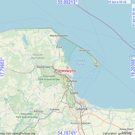
Pierwoszyno GPS coordinates[2]
54° 35' 48.588" North, 18° 29' 59.82" East
| Map corner | latitude | longitude |
|---|---|---|
| Upper-left | 55.00213°, | 17.79683° |
| Center: | 54.59683°, | 18.49995° |
| Lower-right: | 54.18745°, | 19.20308° |
| Map W x H: | 90.6×90.6 km | = 56.3×56.3mi |
| max Lat: | 54.83135° ⇑0.9% North |
| Pierwoszyno: | 54.59683° |
| min Lat: | ⇓99.1% South 49.21328° |
| min Long | Pierwoszyno | max Long |
| 14.20249° | 18.49995° | 24.03723° |
| W 31.9%⇐ | ⇒68.1% E |
Elevation
Elevation of Pierwoszyno is 33 m = 108 ft, and this is 158.4 m = 520 ft below average elevation for this country.
| Max E: |
974 m = 3196 ft | 95.9% |
| Avg. | 191.4 m = 628 ft | |
| Pierwoszyno | 33 m = 108 ft | |
Min E: |
-3 m = -10 ft | 4.1% |
See also: Poland elevation on elevation.city.
Geographical zone
Pierwoszyno is located in North temperate zone (between Tropic of Cancer and the Arctic Circle). Distance of this North polar circle is 1330.6 km =826.8 mi to North.| Distance of | km | miles | from Pierwoszyno |
|---|---|---|---|
| North Pole | 3936.5 | 2446 | to North |
| Arctic Circle | 1330.6 | 826.8 | to North |
| Tropic Cancer | 3464.7 | 2152.9 | to South |
| Equator | 6070.6 | 3772.1 | to South |


Nearby cities:
15 places around Pierwoszyno: (largest is in red/bold)
• Bojano
15.8 km =9.8 mi,  208°
208°
• Dębogórze
2.7 km =1.7 mi,  256°
256°
• Gdynia
8.9 km =5.5 mi,  166°
166°
• Jastarnia
15.9 km =9.9 mi,  46°
46°
• Kosakowo
1.3 km =0.8 mi,  229°
229°
• Mosty
1.7 km =1.1 mi,  352°
352°
• Mrzezino
7.8 km =4.8 mi,  324°
324°
• Pogórze
3.8 km =2.4 mi,  197°
197°
• Puck
14.7 km =9.1 mi,  336°
336°
• Reda
9.9 km =6.2 mi,  275°
275°
• Rekowo Dolne
9.6 km =6 mi,  293°
293°
• Rewa
4.1 km =2.5 mi,  8°
8°
• Rumia
7.8 km =4.8 mi,  248°
248°
• Wielki Kack
14.4 km =8.9 mi,  183°
183°
• Żelistrzewo
10.4 km =6.5 mi,  329°
329°
Sources, notices
• [Note1] Compared only with cities in Poland existing in our database
• [Src1] Map data: © OpenStreetMap contributors (CC-BY-SA)
• [Src2] Other city data from geonames.org with taken over terms of usage.
• [Src3] Geographical zone / Annual Mean Temperature by Robert A. Rohde @ Wikipedia
