Reda geodata
Reda (Pomerania) is a seat of a third-order administrative division; located in Poland in Europe/Warsaw (GMT+2) time zone. With population of 18,116 people, there are 272 cities with bigger population in this country. Compared to other cities in Poland, 99.2% of cities are located further ↓South; 70.5% of cities are located further →East and 98.7% of cities have higher elevation than Reda. Note1


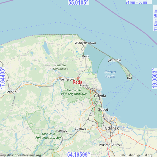
Reda GPS coordinates[2]
54° 36' 19.008" North, 18° 20' 49.812" East
| Map corner | latitude | longitude |
|---|---|---|
| Upper-left | 55.0105°, | 17.64405° |
| Center: | 54.60528°, | 18.34717° |
| Lower-right: | 54.19599°, | 19.0503° |
| Map W x H: | 90.6×90.6 km | = 56.3×56.3mi |
| max Lat: | 54.83135° ⇑0.8% North |
| Reda: | 54.60528° |
| min Lat: | ⇓99.2% South 49.21328° |
| min Long | Reda | max Long |
| 14.20249° | 18.34717° | 24.03723° |
| W 29.5%⇐ | ⇒70.5% E |
Elevation
Elevation of Reda is 7 m = 23 ft, and this is 184.4 m = 605 ft below average elevation for this country.
| Max E: |
974 m = 3196 ft | 98.7% |
| Avg. | 191.4 m = 628 ft | |
| Reda | 7 m = 23 ft | |
Min E: |
-3 m = -10 ft | 1.3% |
See also: Poland elevation on elevation.city.
Geographical zone
Reda is located in North temperate zone (between Tropic of Cancer and the Arctic Circle). Distance of this North polar circle is 1329.6 km =826.2 mi to North.| Distance of | km | miles | from Reda |
|---|---|---|---|
| North Pole | 3935.5 | 2445.4 | to North |
| Arctic Circle | 1329.6 | 826.2 | to North |
| Tropic Cancer | 3465.6 | 2153.4 | to South |
| Equator | 6071.5 | 3772.7 | to South |


Nearby cities:
15 places around Reda: (largest is in red/bold)
• Bolszewo
11.1 km =6.9 mi,  277°
277°
• Dębogórze
7.4 km =4.6 mi,  102°
102°
• Gościcino
12.4 km =7.7 mi,  269°
269°
• Kosakowo
9 km =5.6 mi, 101°
• Mosty
9.6 km =6 mi,  85°
85°
• Mrzezino
7.6 km =4.7 mi,  44°
44°
• Orle
12 km =7.5 mi,  288°
288°
• Pierwoszyno
9.9 km =6.2 mi, 95°
• Pogórze
9.8 km =6.1 mi,  117°
117°
• Puck
13.1 km =8.1 mi,  17°
17°
• Rekowo Dolne
3.1 km =1.9 mi, 19°
• Rewa
10.9 km =6.8 mi,  73°
73°
• Rumia
4.6 km =2.9 mi,  145°
145°
• Wejherowo
7.2 km =4.5 mi, 270°
• Żelistrzewo
9.2 km =5.7 mi,  29°
29°
Sources, notices
• [Note1] Compared only with cities in Poland existing in our database
• [Src1] Map data: © OpenStreetMap contributors (CC-BY-SA)
• [Src2] Other city data from geonames.org with taken over terms of usage.
• [Src3] Geographical zone / Annual Mean Temperature by Robert A. Rohde @ Wikipedia
