Dębogórze geodata
Dębogórze (Pomerania) is a populated place; located in Poland in Europe/Warsaw (GMT+2) time zone. With population of 962 people, there are 2565 cities with bigger population in this country. Compared to other cities in Poland, 99.1% of cities are located further ↓South; 68.8% of cities are located further →East and 93.8% of cities have higher elevation than Dębogórze. Note1


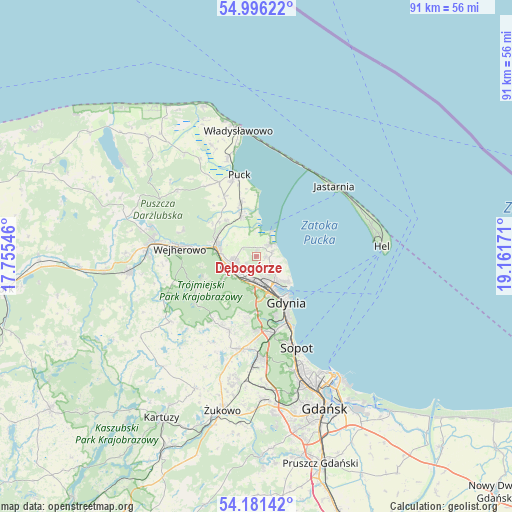
Dębogórze GPS coordinates[2]
54° 35' 27.096" North, 18° 27' 30.888" East
| Map corner | latitude | longitude |
|---|---|---|
| Upper-left | 54.99622°, | 17.75546° |
| Center: | 54.59086°, | 18.45858° |
| Lower-right: | 54.18142°, | 19.16171° |
| Map W x H: | 90.6×90.6 km | = 56.3×56.3mi |
| max Lat: | 54.83135° ⇑0.9% North |
| Dębogórze: | 54.59086° |
| min Lat: | ⇓99.1% South 49.21328° |
| min Long | Dębogórze | max Long |
| 14.20249° | 18.45858° | 24.03723° |
| W 31.2%⇐ | ⇒68.8% E |
Elevation
Elevation of Dębogórze is 55 m = 180 ft, and this is 136.4 m = 448 ft below average elevation for this country.
| Max E: |
974 m = 3196 ft | 93.8% |
| Avg. | 191.4 m = 628 ft | |
| Dębogórze | 55 m = 180 ft | |
Min E: |
-3 m = -10 ft | 6.2% |
See also: Poland elevation on elevation.city.
Geographical zone
Dębogórze is located in North temperate zone (between Tropic of Cancer and the Arctic Circle). Distance of this North polar circle is 1331.2 km =827.2 mi to North.| Distance of | km | miles | from Dębogórze |
|---|---|---|---|
| North Pole | 3937.1 | 2446.4 | to North |
| Arctic Circle | 1331.2 | 827.2 | to North |
| Tropic Cancer | 3464 | 2152.4 | to South |
| Equator | 6069.9 | 3771.7 | to South |


Nearby cities:
15 places around Dębogórze: (largest is in red/bold)
• Bojano
14.1 km =8.8 mi,  199°
199°
• Gdynia
9.3 km =5.8 mi,  149°
149°
• Koleczkowo
13.8 km =8.6 mi,  212°
212°
• Kosakowo
1.7 km =1.1 mi,  95°
95°
• Mosty
3.4 km =2.1 mi,  46°
46°
• Mrzezino
7.2 km =4.5 mi,  345°
345°
• Pierwoszyno
2.7 km =1.7 mi,  76°
76°
• Pogórze
3.3 km =2.1 mi, 152°
• Reda
7.4 km =4.6 mi,  282°
282°
• Rekowo Dolne
7.6 km =4.7 mi,  306°
306°
• Rewa
5.7 km =3.5 mi,  34°
34°
• Rumia
5.1 km =3.2 mi,  244°
244°
• Wejherowo
14.5 km =9 mi, 276°
• Wielki Kack
13.8 km =8.6 mi,  172°
172°
• Żelistrzewo
10 km =6.2 mi,  344°
344°
Sources, notices
• [Note1] Compared only with cities in Poland existing in our database
• [Src1] Map data: © OpenStreetMap contributors (CC-BY-SA)
• [Src2] Other city data from geonames.org with taken over terms of usage.
• [Src3] Geographical zone / Annual Mean Temperature by Robert A. Rohde @ Wikipedia
