Chłapowo geodata
Chłapowo (Pomerania) is a populated place; located in Poland in Europe/Warsaw (GMT+2) time zone. With population of 1,069 people, there are 2390 cities with bigger population in this country. Compared to other cities in Poland, 99.9% of cities are located further ↓South; 70.2% of cities are located further →East and 94.7% of cities have higher elevation than Chłapowo. Note1


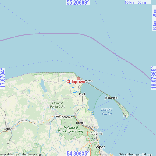
Chłapowo GPS coordinates[2]
54° 48' 13.14" North, 18° 22' 24.672" East
| Map corner | latitude | longitude |
|---|---|---|
| Upper-left | 55.20689°, | 17.6704° |
| Center: | 54.80365°, | 18.37352° |
| Lower-right: | 54.39635°, | 19.07665° |
| Map W x H: | 90.1×90.1 km | = 56×56mi |
| max Lat: | 54.83135° ⇑0.1% North |
| Chłapowo: | 54.80365° |
| min Lat: | ⇓99.9% South 49.21328° |
| min Long | Chłapowo | max Long |
| 14.20249° | 18.37352° | 24.03723° |
| W 29.8%⇐ | ⇒70.2% E |
Elevation
Elevation of Chłapowo is 46 m = 151 ft, and this is 145.4 m = 477 ft below average elevation for this country.
| Max E: |
974 m = 3196 ft | 94.7% |
| Avg. | 191.4 m = 628 ft | |
| Chłapowo | 46 m = 151 ft | |
Min E: |
-3 m = -10 ft | 5.3% |
See also: Poland elevation on elevation.city.
Geographical zone
Chłapowo is located in North temperate zone (between Tropic of Cancer and the Arctic Circle). Distance of this North polar circle is 1307.6 km =812.5 mi to North.| Distance of | km | miles | from Chłapowo |
|---|---|---|---|
| North Pole | 3913.5 | 2431.7 | to North |
| Arctic Circle | 1307.6 | 812.5 | to North |
| Tropic Cancer | 3487.7 | 2167.2 | to South |
| Equator | 6093.6 | 3786.4 | to South |


Nearby cities:
15 places around Chłapowo: (largest is in red/bold)
• Gnieżdżewo
6.3 km =3.9 mi,  176°
176°
• Jastrzębia Góra
5 km =3.1 mi,  308°
308°
• Karwia
10.8 km =6.7 mi,  285°
285°
• Krokowa
13.9 km =8.6 mi,  258°
258°
• Mrzezino
17.1 km =10.6 mi,  167°
167°
• Orle
22.4 km =13.9 mi,  215°
215°
• Ostrowo
8.6 km =5.3 mi, 286°
• Puck
9.8 km =6.1 mi, 166°
• Reda
22.1 km =13.7 mi, 184°
• Rekowo Dolne
19.2 km =11.9 mi, 182°
• Rewa
20.9 km =13 mi,  155°
155°
• Strzelno
3.7 km =2.3 mi,  237°
237°
• Swarzewo
4.9 km =3 mi, 161°
• Władysławowo
2.3 km =1.4 mi,  129°
129°
• Żelistrzewo
14.3 km =8.9 mi, 168°
Sources, notices
• [Note1] Compared only with cities in Poland existing in our database
• [Src1] Map data: © OpenStreetMap contributors (CC-BY-SA)
• [Src2] Other city data from geonames.org with taken over terms of usage.
• [Src3] Geographical zone / Annual Mean Temperature by Robert A. Rohde @ Wikipedia
