Kurów geodata
Kurów (Lesser Poland) is a populated place; located in Poland in Europe/Warsaw (GMT+2) time zone. With population of 583 people, there are 3328 cities with bigger population in this country. Compared to other cities in Poland, 93.9% of cities are located further ↑North; 52.1% of cities are located further →East and 98.1% of cities have lower elevation than Kurów. Note1


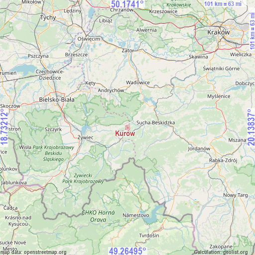
Kurów GPS coordinates[2]
49° 43' 17.94" North, 19° 26' 6.864" East
| Map corner | latitude | longitude |
|---|---|---|
| Upper-left | 50.1741°, | 18.73212° |
| Center: | 49.72165°, | 19.43524° |
| Lower-right: | 49.26495°, | 20.13837° |
| Map W x H: | 101.1×101.1 km | = 62.8×62.8mi |
| max Lat: | 54.83135° ⇑93.9% North |
| Kurów: | 49.72165° |
| min Lat: | ⇓6.1% South 49.21328° |
| min Long | Kurów | max Long |
| 14.20249° | 19.43524° | 24.03723° |
| W 47.9%⇐ | ⇒52.1% E |
Elevation
Elevation of Kurów is 547 m = 1795 ft, and this is 355.6 m = 1167 ft above average elevation for this country.
| Max E: |
974 m = 3196 ft | 1.9% |
| Kurów | 547 m 1795 ft | |
| Avg. | 191.4 m = 628 ft | |
Min E: |
-3 m = -10 ft | 98.1% |
See also: Poland elevation on elevation.city.
Geographical zone
Kurów is located in North temperate zone (between Tropic of Cancer and the Arctic Circle). Distance of this North polar circle is 1872.6 km =1163.6 mi to North.| Distance of | km | miles | from Kurów |
|---|---|---|---|
| North Pole | 4478.5 | 2782.8 | to North |
| Arctic Circle | 1872.6 | 1163.6 | to North |
| Tropic Cancer | 2922.6 | 1816 | to South |
| Equator | 5528.5 | 3435.2 | to South |


Nearby cities:
15 places around Kurów: (largest is in red/bold)
• Gilowice
9 km =5.6 mi,  263°
263°
• Jeleśnia
11.8 km =7.3 mi,  221°
221°
• Koszarawa
8.9 km =5.5 mi,  196°
196°
• Krzeszów
5.7 km =3.5 mi,  42°
42°
• Kuków
3.8 km =2.4 mi,  71°
71°
• Lachowice
2.9 km =1.8 mi,  103°
103°
• Pewel Wielka
6.8 km =4.2 mi, 219°
• Pewel Ślemieńska
8.1 km =5 mi,  243°
243°
• Przyborów
11.7 km =7.3 mi, 197°
• Rzyki
10.4 km =6.5 mi,  344°
344°
• Stryszawa
6.3 km =3.9 mi, 98°
• Sucha Beskidzka
11.7 km =7.3 mi,  78°
78°
• Sułkowice
12.1 km =7.5 mi,  333°
333°
• Zawoja
11.6 km =7.2 mi,  138°
138°
• Ślemień
4.9 km =3 mi,  265°
265°
Sources, notices
• [Note1] Compared only with cities in Poland existing in our database
• [Src1] Map data: © OpenStreetMap contributors (CC-BY-SA)
• [Src2] Other city data from geonames.org with taken over terms of usage.
• [Src3] Geographical zone / Annual Mean Temperature by Robert A. Rohde @ Wikipedia
