Gierałtowice geodata
Gierałtowice (Lesser Poland) is a populated place; located in Poland in Europe/Warsaw (GMT+2) time zone. With population of 1,252 people, there are 2124 cities with bigger population in this country. Compared to other cities in Poland, 85.9% of cities are located further ↑North; 52.9% of cities are located further →East and 86.1% of cities have lower elevation than Gierałtowice. Note1


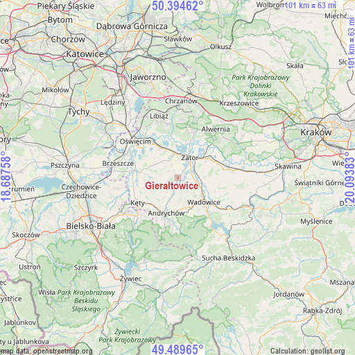
Gierałtowice GPS coordinates[2]
49° 56' 39.336" North, 19° 23' 26.52" East
| Map corner | latitude | longitude |
|---|---|---|
| Upper-left | 50.39462°, | 18.68758° |
| Center: | 49.94426°, | 19.3907° |
| Lower-right: | 49.48965°, | 20.09383° |
| Map W x H: | 100.6×100.6 km | = 62.5×62.5mi |
| max Lat: | 54.83135° ⇑85.9% North |
| Gierałtowice: | 49.94426° |
| min Lat: | ⇓14.1% South 49.21328° |
| min Long | Gierałtowice | max Long |
| 14.20249° | 19.3907° | 24.03723° |
| W 47.1%⇐ | ⇒52.9% E |
Elevation
Elevation of Gierałtowice is 296 m = 971 ft, and this is 104.6 m = 343 ft above average elevation for this country.
| Max E: |
974 m = 3196 ft | 13.9% |
| Gierałtowice | 296 m 971 ft | |
| Avg. | 191.4 m = 628 ft | |
Min E: |
-3 m = -10 ft | 86.1% |
See also: Poland elevation on elevation.city.
Geographical zone
Gierałtowice is located in North temperate zone (between Tropic of Cancer and the Arctic Circle). Distance of this North polar circle is 1847.9 km =1148.2 mi to North.| Distance of | km | miles | from Gierałtowice |
|---|---|---|---|
| North Pole | 4453.8 | 2767.5 | to North |
| Arctic Circle | 1847.9 | 1148.2 | to North |
| Tropic Cancer | 2947.4 | 1831.4 | to South |
| Equator | 5553.3 | 3450.7 | to South |


Nearby cities:
15 places around Gierałtowice: (largest is in red/bold)
• Bachowice
7.5 km =4.7 mi,  78°
78°
• Chocznia
9 km =5.6 mi,  149°
149°
• Frydrychowice
4.8 km =3 mi, 154°
• Graboszyce
4.2 km =2.6 mi,  88°
88°
• Inwałd
9 km =5.6 mi,  179°
179°
• Nidek
6.4 km =4 mi,  227°
227°
• Osiek
9.1 km =5.7 mi,  274°
274°
• Polanka Wielka
6.5 km =4 mi,  314°
314°
• Przeciszów
7 km =4.3 mi,  351°
351°
• Radocza
6.7 km =4.2 mi,  116°
116°
• Tomice
8.4 km =5.2 mi,  127°
127°
• Wieprz
6.4 km =4 mi,  202°
202°
• Witkowice
8.9 km =5.5 mi,  242°
242°
• Woźniki
7.2 km =4.5 mi,  95°
95°
• Zator
6.7 km =4.2 mi,  30°
30°
Sources, notices
• [Note1] Compared only with cities in Poland existing in our database
• [Src1] Map data: © OpenStreetMap contributors (CC-BY-SA)
• [Src2] Other city data from geonames.org with taken over terms of usage.
• [Src3] Geographical zone / Annual Mean Temperature by Robert A. Rohde @ Wikipedia
