Spytkowice geodata
Spytkowice (Lesser Poland) is a populated place; located in Poland in Europe/Warsaw (GMT+2) time zone. With population of 3,898 people, there are 837 cities with bigger population in this country. Compared to other cities in Poland, 82.5% of cities are located further ↑North; 50.9% of cities are located further →East and 69.4% of cities have lower elevation than Spytkowice. Note1


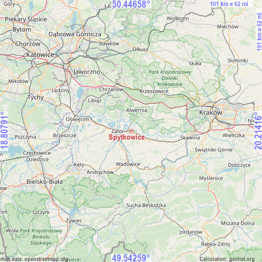
Spytkowice GPS coordinates[2]
49° 59' 48.156" North, 19° 30' 39.708" East
| Map corner | latitude | longitude |
|---|---|---|
| Upper-left | 50.44658°, | 18.80791° |
| Center: | 49.99671°, | 19.51103° |
| Lower-right: | 49.54259°, | 20.21416° |
| Map W x H: | 100.5×100.5 km | = 62.4×62.4mi |
| max Lat: | 54.83135° ⇑82.5% North |
| Spytkowice: | 49.99671° |
| min Lat: | ⇓17.5% South 49.21328° |
| min Long | Spytkowice | max Long |
| 14.20249° | 19.51103° | 24.03723° |
| W 49.1%⇐ | ⇒50.9% E |
Elevation
Elevation of Spytkowice is 227 m = 745 ft, and this is 35.6 m = 117 ft above average elevation for this country.
| Max E: |
974 m = 3196 ft | 30.6% |
| Spytkowice | 227 m 745 ft | |
| Avg. | 191.4 m = 628 ft | |
Min E: |
-3 m = -10 ft | 69.4% |
See also: Poland elevation on elevation.city.
Geographical zone
Spytkowice is located in North temperate zone (between Tropic of Cancer and the Arctic Circle). Distance of this North polar circle is 1842.1 km =1144.6 mi to North.| Distance of | km | miles | from Spytkowice |
|---|---|---|---|
| North Pole | 4447.9 | 2763.8 | to North |
| Arctic Circle | 1842.1 | 1144.6 | to North |
| Tropic Cancer | 2953.2 | 1835 | to South |
| Equator | 5559.1 | 3454.3 | to South |


Nearby cities:
15 places around Spytkowice: (largest is in red/bold)
• Alwernia
7.4 km =4.6 mi,  15°
15°
• Bachowice
4.5 km =2.8 mi,  196°
196°
• Brodła
7.6 km =4.7 mi,  46°
46°
• Graboszyce
7.2 km =4.5 mi,  217°
217°
• Jankowice
7.2 km =4.5 mi,  316°
316°
• Kamień
5.6 km =3.5 mi,  72°
72°
• Kwaczała
7.6 km =4.7 mi,  349°
349°
• Okleśna
4.1 km =2.5 mi, 20°
• Olszyny
7.5 km =4.7 mi,  326°
326°
• Rozkochów
5.6 km =3.5 mi,  344°
344°
• Rusocice
6.8 km =4.2 mi,  90°
90°
• Ryczów
3.3 km =2.1 mi,  121°
121°
• Woźniki
6.7 km =4.2 mi,  192°
192°
• Zator
5.2 km =3.2 mi,  269°
269°
• Łączany
5 km =3.1 mi,  106°
106°
Sources, notices
• [Note1] Compared only with cities in Poland existing in our database
• [Src1] Map data: © OpenStreetMap contributors (CC-BY-SA)
• [Src2] Other city data from geonames.org with taken over terms of usage.
• [Src3] Geographical zone / Annual Mean Temperature by Robert A. Rohde @ Wikipedia
