Graboszyce geodata
Graboszyce (Lesser Poland) is a populated place; located in Poland in Europe/Warsaw (GMT+2) time zone. With population of 742 people, there are 2990 cities with bigger population in this country. Compared to other cities in Poland, 85.8% of cities are located further ↑North; 51.9% of cities are located further →East and 75.1% of cities have lower elevation than Graboszyce. Note1


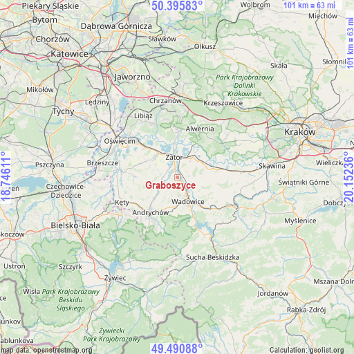
Graboszyce GPS coordinates[2]
49° 56' 43.728" North, 19° 26' 57.228" East
| Map corner | latitude | longitude |
|---|---|---|
| Upper-left | 50.39583°, | 18.74611° |
| Center: | 49.94548°, | 19.44923° |
| Lower-right: | 49.49088°, | 20.15236° |
| Map W x H: | 100.6×100.6 km | = 62.5×62.5mi |
| max Lat: | 54.83135° ⇑85.8% North |
| Graboszyce: | 49.94548° |
| min Lat: | ⇓14.2% South 49.21328° |
| min Long | Graboszyce | max Long |
| 14.20249° | 19.44923° | 24.03723° |
| W 48.1%⇐ | ⇒51.9% E |
Elevation
Elevation of Graboszyce is 247 m = 810 ft, and this is 55.6 m = 182 ft above average elevation for this country.
| Max E: |
974 m = 3196 ft | 24.9% |
| Graboszyce | 247 m 810 ft | |
| Avg. | 191.4 m = 628 ft | |
Min E: |
-3 m = -10 ft | 75.1% |
See also: Poland elevation on elevation.city.
Geographical zone
Graboszyce is located in North temperate zone (between Tropic of Cancer and the Arctic Circle). Distance of this North polar circle is 1847.8 km =1148.2 mi to North.| Distance of | km | miles | from Graboszyce |
|---|---|---|---|
| North Pole | 4453.6 | 2767.3 | to North |
| Arctic Circle | 1847.8 | 1148.2 | to North |
| Tropic Cancer | 2947.5 | 1831.5 | to South |
| Equator | 5553.4 | 3450.7 | to South |


Nearby cities:
15 places around Graboszyce: (largest is in red/bold)
• Bachowice
3.5 km =2.2 mi,  66°
66°
• Chocznia
7.9 km =4.9 mi,  177°
177°
• Frydrychowice
5 km =3.1 mi,  205°
205°
• Gierałtowice
4.2 km =2.6 mi,  268°
268°
• Klecza Dolna
9.4 km =5.8 mi,  137°
137°
• Przeciszów
8.6 km =5.3 mi,  322°
322°
• Radocza
3.6 km =2.2 mi,  149°
149°
• Ryczów
8.2 km =5.1 mi,  61°
61°
• Spytkowice
7.2 km =4.5 mi,  37°
37°
• Tomice
5.9 km =3.7 mi,  155°
155°
• Wadowice
7.6 km =4.7 mi, 155°
• Wieprz
9 km =5.6 mi,  227°
227°
• Witanowice
6.3 km =3.9 mi,  119°
119°
• Woźniki
3.1 km =1.9 mi,  106°
106°
• Zator
5.7 km =3.5 mi,  351°
351°
Sources, notices
• [Note1] Compared only with cities in Poland existing in our database
• [Src1] Map data: © OpenStreetMap contributors (CC-BY-SA)
• [Src2] Other city data from geonames.org with taken over terms of usage.
• [Src3] Geographical zone / Annual Mean Temperature by Robert A. Rohde @ Wikipedia
