Morąg geodata
Morąg (Warmia-Masuria) is a seat of a third-order administrative division; located in Poland in Europe/Warsaw (GMT+2) time zone. With population of 14,745 people, there are 342 cities with bigger population in this country. Compared to other cities in Poland, 93.3% of cities are located further ↓South; 57.1% of cities are located further ←West and 72.1% of cities have higher elevation than Morąg. Note1


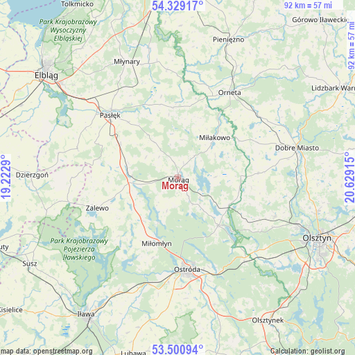
Morąg GPS coordinates[2]
53° 55' 1.596" North, 19° 55' 33.672" East
| Map corner | latitude | longitude |
|---|---|---|
| Upper-left | 54.32917°, | 19.2229° |
| Center: | 53.91711°, | 19.92602° |
| Lower-right: | 53.50094°, | 20.62915° |
| Map W x H: | 92.1×92.1 km | = 57.2×57.2mi |
| max Lat: | 54.83135° ⇑6.7% North |
| Morąg: | 53.91711° |
| min Lat: | ⇓93.3% South 49.21328° |
| min Long | Morąg | max Long |
| 14.20249° | 19.92602° | 24.03723° |
| W 57.1%⇐ | ⇒42.9% E |
Elevation
Elevation of Morąg is 117 m = 384 ft, and this is 74.4 m = 244 ft below average elevation for this country.
| Max E: |
974 m = 3196 ft | 72.1% |
| Avg. | 191.4 m = 628 ft | |
| Morąg | 117 m = 384 ft | |
Min E: |
-3 m = -10 ft | 27.9% |
See also: Poland elevation on elevation.city.
Geographical zone
Morąg is located in North temperate zone (between Tropic of Cancer and the Arctic Circle). Distance of this North polar circle is 1406.2 km =873.8 mi to North.| Distance of | km | miles | from Morąg |
|---|---|---|---|
| North Pole | 4012 | 2492.9 | to North |
| Arctic Circle | 1406.2 | 873.8 | to North |
| Tropic Cancer | 3389.1 | 2105.9 | to South |
| Equator | 5995 | 3725.1 | to South |


Nearby cities:
15 places around Morąg: (largest is in red/bold)
• Dobre Miasto
31.8 km =19.8 mi,  75°
75°
• Gietrzwałd
27.9 km =17.3 mi,  132°
132°
• Jonkowo
27.1 km =16.8 mi,  111°
111°
• Lubomino
26.4 km =16.4 mi,  50°
50°
• Małdyty
11.9 km =7.4 mi,  271°
271°
• Miłakowo
14 km =8.7 mi,  42°
42°
• Miłomłyn
17.9 km =11.1 mi,  198°
198°
• Młynary
32.8 km =20.4 mi,  336°
336°
• Orneta
25.8 km =16 mi,  31°
31°
• Ostróda
24.6 km =15.3 mi,  174°
174°
• Pasłęk
23.7 km =14.7 mi,  312°
312°
• Rychliki
27.1 km =16.8 mi,  286°
286°
• Zalewo
22.5 km =14 mi,  249°
249°
• Łukta
16.2 km =10.1 mi,  140°
140°
• Świątki
20.8 km =12.9 mi,  86°
86°
Sources, notices
• [Note1] Compared only with cities in Poland existing in our database
• [Src1] Map data: © OpenStreetMap contributors (CC-BY-SA)
• [Src2] Other city data from geonames.org with taken over terms of usage.
• [Src3] Geographical zone / Annual Mean Temperature by Robert A. Rohde @ Wikipedia
