Miłakowo geodata
Miłakowo (Warmia-Masuria) is a seat of a third-order administrative division; located in Poland in Europe/Warsaw (GMT+2) time zone. With population of 2,691 people, there are 1173 cities with bigger population in this country. Compared to other cities in Poland, 94.3% of cities are located further ↓South; 59.4% of cities are located further ←West and 85.7% of cities have higher elevation than Miłakowo. Note1


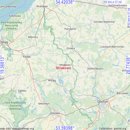
Miłakowo GPS coordinates[2]
54° 0' 33.228" North, 20° 4' 16.5" East
| Map corner | latitude | longitude |
|---|---|---|
| Upper-left | 54.42038°, | 19.36813° |
| Center: | 54.00923°, | 20.07125° |
| Lower-right: | 53.59398°, | 20.77438° |
| Map W x H: | 91.9×91.9 km | = 57.1×57.1mi |
| max Lat: | 54.83135° ⇑5.7% North |
| Miłakowo: | 54.00923° |
| min Lat: | ⇓94.3% South 49.21328° |
| min Long | Miłakowo | max Long |
| 14.20249° | 20.07125° | 24.03723° |
| W 59.4%⇐ | ⇒40.6% E |
Elevation
Elevation of Miłakowo is 88 m = 289 ft, and this is 103.4 m = 339 ft below average elevation for this country.
| Max E: |
974 m = 3196 ft | 85.7% |
| Avg. | 191.4 m = 628 ft | |
| Miłakowo | 88 m = 289 ft | |
Min E: |
-3 m = -10 ft | 14.3% |
See also: Poland elevation on elevation.city.
Geographical zone
Miłakowo is located in North temperate zone (between Tropic of Cancer and the Arctic Circle). Distance of this North polar circle is 1395.9 km =867.4 mi to North.| Distance of | km | miles | from Miłakowo |
|---|---|---|---|
| North Pole | 4001.8 | 2486.6 | to North |
| Arctic Circle | 1395.9 | 867.4 | to North |
| Tropic Cancer | 3399.3 | 2112.2 | to South |
| Equator | 6005.3 | 3731.5 | to South |


Nearby cities:
15 places around Miłakowo: (largest is in red/bold)
• Dobre Miasto
21.5 km =13.4 mi,  96°
96°
• Dywity
32.8 km =20.4 mi,  125°
125°
• Gietrzwałd
31.2 km =19.4 mi,  159°
159°
• Jonkowo
25.5 km =15.8 mi,  142°
142°
• Lubomino
12.7 km =7.9 mi,  59°
59°
• Małdyty
23.6 km =14.7 mi,  245°
245°
• Miłomłyn
31.2 km =19.4 mi,  209°
209°
• Morąg
14 km =8.7 mi,  222°
222°
• Młynary
30.2 km =18.8 mi,  310°
310°
• Orneta
12.4 km =7.7 mi,  19°
19°
• Pasłęk
27.5 km =17.1 mi,  282°
282°
• Pieniężno
25.5 km =15.8 mi,  8°
8°
• Spręcowo
27.9 km =17.3 mi,  120°
120°
• Łukta
22.7 km =14.1 mi,  177°
177°
• Świątki
14.5 km =9 mi, 129°
Sources, notices
• [Note1] Compared only with cities in Poland existing in our database
• [Src1] Map data: © OpenStreetMap contributors (CC-BY-SA)
• [Src2] Other city data from geonames.org with taken over terms of usage.
• [Src3] Geographical zone / Annual Mean Temperature by Robert A. Rohde @ Wikipedia
