Ostrów Wielkopolski geodata
Ostrów Wielkopolski (Greater Poland) is a seat of a second-order administrative division; located in Poland in Europe/Warsaw (GMT+2) time zone. With population of 72,898 people, there are 65 cities with bigger population in this country. Compared to other cities in Poland, 59.3% of cities are located further ↓South; 77.2% of cities are located further →East and 66.1% of cities have higher elevation than Ostrów Wielkopolski. Note1
Administrative division(s):
- Level 1: Greater Poland
- Level 2: Powiat ostrowski
- Level 3: Ostrów Wielkopolski


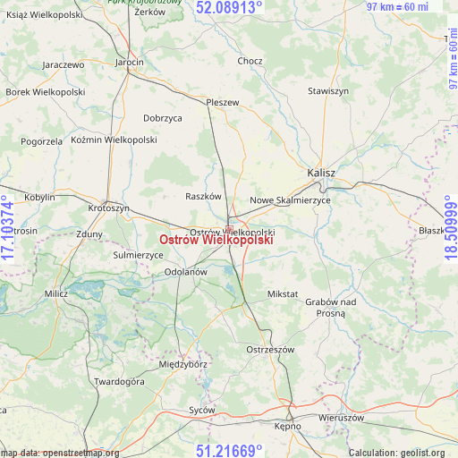
Ostrów Wielkopolski GPS coordinates[2]
51° 39' 18.036" North, 17° 48' 24.696" East
| Map corner | latitude | longitude |
|---|---|---|
| Upper-left | 52.08913°, | 17.10374° |
| Center: | 51.65501°, | 17.80686° |
| Lower-right: | 51.21669°, | 18.50999° |
| Map W x H: | 97×97 km | = 60.3×60.3mi |
| max Lat: | 54.83135° ⇑40.7% North |
| Ostrów Wielkopolski: | 51.65501° |
| min Lat: | ⇓59.3% South 49.21328° |
| min Long | Ostrów Wielkop | max Long |
| 14.20249° | 17.80686° | 24.03723° |
| W 22.8%⇐ | ⇒77.2% E |
Elevation
Elevation of Ostrów Wielkopolski is 130 m = 427 ft, and this is 61.4 m = 201 ft below average elevation for this country.
| Max E: |
974 m = 3196 ft | 66.1% |
| Avg. | 191.4 m = 628 ft | |
| Ostrów Wielkopolski | 130 m = 427 ft | |
Min E: |
-3 m = -10 ft | 33.9% |
See also: Ostrów Wielkopolski elevation on elevation.city.
Geographical zone
Ostrów Wielkopolski is located in North temperate zone (between Tropic of Cancer and the Arctic Circle). Distance of this North polar circle is 1657.7 km =1030 mi to North.| Distance of | km | miles | from Ostrów Wielkopolski |
|---|---|---|---|
| North Pole | 4263.6 | 2649.3 | to North |
| Arctic Circle | 1657.7 | 1030 | to North |
| Tropic Cancer | 3137.6 | 1949.6 | to South |
| Equator | 5743.5 | 3568.8 | to South |


Nearby cities:
15 places around Ostrów Wielkopolski: (largest is in red/bold)
• Garki
17.3 km =10.7 mi,  220°
220°
• Gorzyce Wielkie
5.7 km =3.5 mi,  249°
249°
• Janków Przygodzki
6.5 km =4 mi,  191°
191°
• Korytnica
14.4 km =8.9 mi,  332°
332°
• Moszczanka
8.5 km =5.3 mi, 326°
• Nowe Skalmierzyce
14.3 km =8.9 mi,  64°
64°
• Odolanów
12.8 km =8 mi,  225°
225°
• Przybysławice
8.6 km =5.3 mi,  311°
311°
• Przygodzice
7.1 km =4.4 mi,  170°
170°
• Psary
14.2 km =8.8 mi,  88°
88°
• Raszków
9 km =5.6 mi,  321°
321°
• Sieroszewice
11.6 km =7.2 mi,  101°
101°
• Skalmierzyce
11.9 km =7.4 mi, 64°
• Sobótka
14.4 km =8.9 mi,  14°
14°
• Wierzbno
9.8 km =6.1 mi,  258°
258°
Sources, notices
• [Note1] Compared only with cities in Poland existing in our database
• [Src1] Map data: © OpenStreetMap contributors (CC-BY-SA)
• [Src2] Other city data from geonames.org with taken over terms of usage.
• [Src3] Geographical zone / Annual Mean Temperature by Robert A. Rohde @ Wikipedia
