Sobótka geodata
Sobótka (Greater Poland) is a populated place; located in Poland in Europe/Warsaw (GMT+2) time zone. With population of 1,000 people, there are 2459 cities with bigger population in this country. Compared to other cities in Poland, 61.7% of cities are located further ↓South; 76.6% of cities are located further →East and 62.1% of cities have higher elevation than Sobótka. Note1
Administrative division(s):
- Level 1: Greater Poland
- Level 2: Powiat ostrowski
- Level 3: Ostrów Wielkopolski


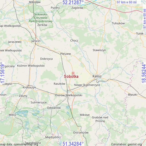
Sobótka GPS coordinates[2]
51° 46' 47.82" North, 17° 51' 33.516" East
| Map corner | latitude | longitude |
|---|---|---|
| Upper-left | 52.21287°, | 17.15619° |
| Center: | 51.77995°, | 17.85931° |
| Lower-right: | 51.34284°, | 18.56244° |
| Map W x H: | 96.7×96.7 km | = 60.1×60.1mi |
| max Lat: | 54.83135° ⇑38.3% North |
| Sobótka: | 51.77995° |
| min Lat: | ⇓61.7% South 49.21328° |
| min Long | Sobótka | max Long |
| 14.20249° | 17.85931° | 24.03723° |
| W 23.4%⇐ | ⇒76.6% E |
Elevation
Elevation of Sobótka is 142 m = 466 ft, and this is 49.4 m = 162 ft below average elevation for this country.
| Max E: |
974 m = 3196 ft | 62.1% |
| Avg. | 191.4 m = 628 ft | |
| Sobótka | 142 m = 466 ft | |
Min E: |
-3 m = -10 ft | 37.9% |
See also: Poland elevation on elevation.city.
Geographical zone
Sobótka is located in North temperate zone (between Tropic of Cancer and the Arctic Circle). Distance of this North polar circle is 1643.8 km =1021.4 mi to North.| Distance of | km | miles | from Sobótka |
|---|---|---|---|
| North Pole | 4249.7 | 2640.6 | to North |
| Arctic Circle | 1643.8 | 1021.4 | to North |
| Tropic Cancer | 3151.5 | 1958.3 | to South |
| Equator | 5757.4 | 3577.5 | to South |


Nearby cities:
15 places around Sobótka: (largest is in red/bold)
• Blizanów
17.2 km =10.7 mi,  36°
36°
• Gorzyce Wielkie
18.2 km =11.3 mi,  209°
209°
• Gołuchów
9.3 km =5.8 mi,  32°
32°
• Kalisz
16.1 km =10 mi,  97°
97°
• Korytnica
10.3 km =6.4 mi,  263°
263°
• Moszczanka
10.8 km =6.7 mi,  230°
230°
• Nowe Skalmierzyce
12 km =7.5 mi,  129°
129°
• Ostrów Wielkopolski
14.4 km =8.9 mi,  194°
194°
• Pleszew
13.9 km =8.6 mi,  338°
338°
• Przybysławice
13 km =8.1 mi, 230°
• Psary
17.2 km =10.7 mi,  142°
142°
• Raszków
11.5 km =7.1 mi, 233°
• Sieroszewice
18 km =11.2 mi,  154°
154°
• Skalmierzyce
11.3 km =7 mi, 140°
• Sośnica
15.2 km =9.4 mi,  306°
306°
Sources, notices
• [Note1] Compared only with cities in Poland existing in our database
• [Src1] Map data: © OpenStreetMap contributors (CC-BY-SA)
• [Src2] Other city data from geonames.org with taken over terms of usage.
• [Src3] Geographical zone / Annual Mean Temperature by Robert A. Rohde @ Wikipedia
