Psary geodata
Psary (Greater Poland) is a populated place; located in Poland in Europe/Warsaw (GMT+2) time zone. With population of 865 people, there are 2738 cities with bigger population in this country. Compared to other cities in Poland, 59.4% of cities are located further ↓South; 75% of cities are located further →East and 69.8% of cities have higher elevation than Psary. Note1


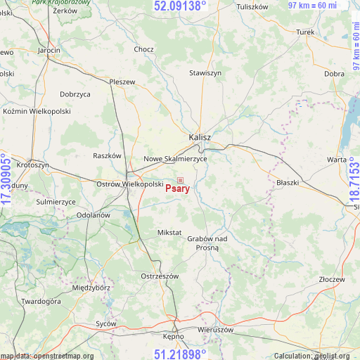
Psary GPS coordinates[2]
51° 39' 26.208" North, 18° 0' 43.812" East
| Map corner | latitude | longitude |
|---|---|---|
| Upper-left | 52.09138°, | 17.30905° |
| Center: | 51.65728°, | 18.01217° |
| Lower-right: | 51.21898°, | 18.7153° |
| Map W x H: | 97×97 km | = 60.3×60.3mi |
| max Lat: | 54.83135° ⇑40.6% North |
| Psary: | 51.65728° |
| min Lat: | ⇓59.4% South 49.21328° |
| min Long | Psary | max Long |
| 14.20249° | 18.01217° | 24.03723° |
| W 25%⇐ | ⇒75% E |
Elevation
Elevation of Psary is 121 m = 397 ft, and this is 70.4 m = 231 ft below average elevation for this country.
| Max E: |
974 m = 3196 ft | 69.8% |
| Avg. | 191.4 m = 628 ft | |
| Psary | 121 m = 397 ft | |
Min E: |
-3 m = -10 ft | 30.2% |
See also: Poland elevation on elevation.city.
Geographical zone
Psary is located in North temperate zone (between Tropic of Cancer and the Arctic Circle). Distance of this North polar circle is 1657.4 km =1029.9 mi to North.| Distance of | km | miles | from Psary |
|---|---|---|---|
| North Pole | 4263.3 | 2649.1 | to North |
| Arctic Circle | 1657.4 | 1029.9 | to North |
| Tropic Cancer | 3137.8 | 1949.7 | to South |
| Equator | 5743.8 | 3569 | to South |


Nearby cities:
15 places around Psary: (largest is in red/bold)
• Brzeziny
18.1 km =11.2 mi,  112°
112°
• Dębe
20.1 km =12.5 mi,  38°
38°
• Godziesze Wielkie
11.2 km =7 mi,  97°
97°
• Gorzyce Wielkie
19.6 km =12.2 mi,  263°
263°
• Grabów nad Prosną
18.4 km =11.4 mi,  156°
156°
• Janków Przygodzki
16.8 km =10.4 mi,  246°
246°
• Kalisz
12.8 km =8 mi,  25°
25°
• Mikstat
14.1 km =8.8 mi,  190°
190°
• Nowe Skalmierzyce
6 km =3.7 mi,  347°
347°
• Opatówek
16.8 km =10.4 mi,  56°
56°
• Ostrów Wielkopolski
14.2 km =8.8 mi,  268°
268°
• Przygodzice
14.9 km =9.3 mi,  240°
240°
• Sieroszewice
3.8 km =2.4 mi,  226°
226°
• Skalmierzyce
5.9 km =3.7 mi,  325°
325°
• Sobótka
17.2 km =10.7 mi,  322°
322°
Sources, notices
• [Note1] Compared only with cities in Poland existing in our database
• [Src1] Map data: © OpenStreetMap contributors (CC-BY-SA)
• [Src2] Other city data from geonames.org with taken over terms of usage.
• [Src3] Geographical zone / Annual Mean Temperature by Robert A. Rohde @ Wikipedia
