Raszków geodata
Raszków (Greater Poland) is a seat of a third-order administrative division; located in Poland in Europe/Warsaw (GMT+2) time zone. With population of 2,079 people, there are 1439 cities with bigger population in this country. Compared to other cities in Poland, 60.5% of cities are located further ↓South; 78% of cities are located further →East and 62.4% of cities have higher elevation than Raszków. Note1


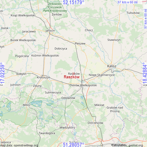
Raszków GPS coordinates[2]
51° 43' 5.808" North, 17° 43' 32.556" East
| Map corner | latitude | longitude |
|---|---|---|
| Upper-left | 52.15179°, | 17.02259° |
| Center: | 51.71828°, | 17.72571° |
| Lower-right: | 51.28057°, | 18.42884° |
| Map W x H: | 96.9×96.9 km | = 60.2×60.2mi |
| max Lat: | 54.83135° ⇑39.5% North |
| Raszków: | 51.71828° |
| min Lat: | ⇓60.5% South 49.21328° |
| min Long | Raszków | max Long |
| 14.20249° | 17.72571° | 24.03723° |
| W 22%⇐ | ⇒78% E |
Elevation
Elevation of Raszków is 141 m = 463 ft, and this is 50.4 m = 165 ft below average elevation for this country.
| Max E: |
974 m = 3196 ft | 62.4% |
| Avg. | 191.4 m = 628 ft | |
| Raszków | 141 m = 463 ft | |
Min E: |
-3 m = -10 ft | 37.6% |
See also: Poland elevation on elevation.city.
Geographical zone
Raszków is located in North temperate zone (between Tropic of Cancer and the Arctic Circle). Distance of this North polar circle is 1650.6 km =1025.6 mi to North.| Distance of | km | miles | from Raszków |
|---|---|---|---|
| North Pole | 4256.5 | 2644.9 | to North |
| Arctic Circle | 1650.6 | 1025.6 | to North |
| Tropic Cancer | 3144.6 | 1954 | to South |
| Equator | 5750.5 | 3573.2 | to South |


Nearby cities:
15 places around Raszków: (largest is in red/bold)
• Gorzyce Wielkie
9 km =5.6 mi,  178°
178°
• Janków Przygodzki
14 km =8.7 mi,  162°
162°
• Korytnica
5.9 km =3.7 mi,  349°
349°
• Moszczanka
0.8 km =0.5 mi,  86°
86°
• Nowe Skalmierzyce
18.5 km =11.5 mi, 92°
• Odolanów
16.4 km =10.2 mi,  192°
192°
• Ostrów Wielkopolski
9 km =5.6 mi,  141°
141°
• Przybysławice
1.6 km =1 mi,  212°
212°
• Przygodzice
15.6 km =9.7 mi,  154°
154°
• Rozdrażew
16.8 km =10.4 mi,  295°
295°
• Skalmierzyce
16.5 km =10.3 mi,  96°
96°
• Sobótka
11.5 km =7.1 mi,  53°
53°
• Sośnica
16.2 km =10.1 mi, 348°
• Sulmierzyce
18.4 km =11.4 mi,  227°
227°
• Wierzbno
9.8 km =6.1 mi,  204°
204°
Sources, notices
• [Note1] Compared only with cities in Poland existing in our database
• [Src1] Map data: © OpenStreetMap contributors (CC-BY-SA)
• [Src2] Other city data from geonames.org with taken over terms of usage.
• [Src3] Geographical zone / Annual Mean Temperature by Robert A. Rohde @ Wikipedia
