Wierzbno geodata
Wierzbno (Greater Poland) is a populated place; located in Poland in Europe/Warsaw (GMT+2) time zone. With population of 554 people, there are 3400 cities with bigger population in this country. Compared to other cities in Poland, 58.8% of cities are located further ↓South; 78.6% of cities are located further →East and 63.7% of cities have higher elevation than Wierzbno. Note1


Wierzbno GPS coordinates[2]
51° 38' 16.404" North, 17° 40' 4.152" East
| Map corner | latitude | longitude |
|---|---|---|
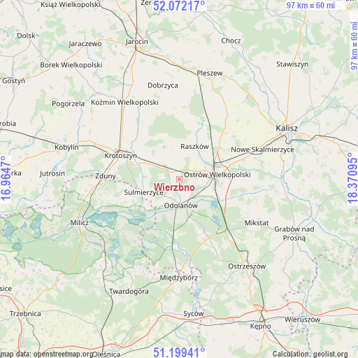
| Upper-left | 52.07217°, | 16.9647° |
| Center: | 51.63789°, | 17.66782° |
| Lower-right: | 51.19941°, | 18.37095° |
| Map W x H: | 97×97 km | = 60.3×60.3mi |
| max Lat: | 54.83135° ⇑41.2% North |
| Wierzbno: | 51.63789° |
| min Lat: | ⇓58.8% South 49.21328° |
| min Long | Wierzbno | max Long |
| 14.20249° | 17.66782° | 24.03723° |
| W 21.4%⇐ | ⇒78.6% E |
Elevation
Elevation of Wierzbno is 137 m = 449 ft, and this is 54.4 m = 178 ft below average elevation for this country.
| Max E: |
974 m = 3196 ft | 63.7% |
| Avg. | 191.4 m = 628 ft | |
| Wierzbno | 137 m = 449 ft | |
Min E: |
-3 m = -10 ft | 36.3% |
See also: Poland elevation on elevation.city.
Geographical zone
Wierzbno is located in North temperate zone (between Tropic of Cancer and the Arctic Circle). Distance of this North polar circle is 1659.6 km =1031.2 mi to North.| Distance of | km | miles | from Wierzbno |
|---|---|---|---|
| North Pole | 4265.5 | 2650.5 | to North |
| Arctic Circle | 1659.6 | 1031.2 | to North |
| Tropic Cancer | 3135.7 | 1948.4 | to South |
| Equator | 5741.6 | 3567.7 | to South |


Nearby cities:
15 places around Wierzbno: (largest is in red/bold)
• Garki
11.3 km =7 mi,  188°
188°
• Gorzyce Wielkie
4.3 km =2.7 mi,  90°
90°
• Janków Przygodzki
9.4 km =5.8 mi,  118°
118°
• Korytnica
15 km =9.3 mi,  11°
11°
• Krotoszyn
17.3 km =10.7 mi,  293°
293°
• Moszczanka
10.2 km =6.3 mi,  28°
28°
• Odolanów
7.1 km =4.4 mi,  176°
176°
• Ostrów Wielkopolski
9.8 km =6.1 mi,  78°
78°
• Przybysławice
8.2 km =5.1 mi,  22°
22°
• Przygodzice
11.9 km =7.4 mi, 115°
• Raszków
9.8 km =6.1 mi, 24°
• Rozdrażew
19.6 km =12.2 mi,  325°
325°
• Sośnie
18.5 km =11.5 mi, 187°
• Sulmierzyce
10.1 km =6.3 mi,  249°
249°
• Zduny
20.1 km =12.5 mi,  272°
272°
Sources, notices
• [Note1] Compared only with cities in Poland existing in our database
• [Src1] Map data: © OpenStreetMap contributors (CC-BY-SA)
• [Src2] Other city data from geonames.org with taken over terms of usage.
• [Src3] Geographical zone / Annual Mean Temperature by Robert A. Rohde @ Wikipedia
